Belley geodata
Belley (Auvergne-Rhône-Alpes) is a seat of a third-order administrative division; located in France in Europe/Paris (GMT+2) time zone. With population of 9,145 people, there are 1051 cities with bigger population in this country. Compared to other cities in France, 69.9% of cities are located further ↑North; 84.3% of cities are located further ←West and 78.1% of cities have lower elevation than Belley. Note1
Administrative division(s):
- Level 1: Auvergne-Rhône-Alpes
- Level 2: Département de l'Ain
- Level 3: Arrondissement de Belley
- Level 4: Belley


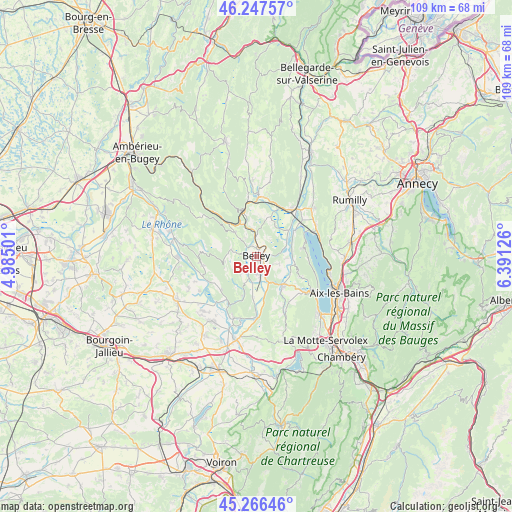
Belley GPS coordinates[2]
45° 45' 33.012" North, 5° 41' 17.268" East
| Map corner | latitude | longitude |
|---|---|---|
| Upper-left | 46.24757°, | 4.98501° |
| Center: | 45.75917°, | 5.68813° |
| Lower-right: | 45.26646°, | 6.39126° |
| Map W x H: | 109.1×109.1 km | = 67.8×67.8mi |
| max Lat: | 51.07786° ⇑69.9% North |
| Belley: | 45.75917° |
| min Lat: | ⇓30.1% South 41.3874° |
| min Long | Belley | max Long |
| -5.08615° | 5.68813° | 9.52242° |
| W 84.3%⇐ | ⇒15.7% E |
Elevation
Elevation of Belley is 273 m = 896 ft, and this is 79.3 m = 260 ft above average elevation for this country.
| Max E: |
2333 m = 7654 ft | 21.9% |
| Belley | 273 m 896 ft | |
| Avg. | 193.7 m = 635 ft | |
Min E: |
-1 m = -3 ft | 78.1% |
See also: France elevation on elevation.city.
Geographical zone
Belley is located in North temperate zone (between Tropic of Cancer and the Arctic Circle). Distance of this North polar circle is 2313.2 km =1437.4 mi to North.| Distance of | km | miles | from Belley |
|---|---|---|---|
| North Pole | 4919.1 | 3056.6 | to North |
| Arctic Circle | 2313.2 | 1437.4 | to North |
| Tropic Cancer | 2482 | 1542.2 | to South |
| Equator | 5087.9 | 3161.5 | to South |


Nearby cities:
15 places around Belley: (largest is in red/bold)
• Artemare
12.8 km =8 mi,  1°
1°
• Brens
3.2 km =2 mi,  175°
175°
• Ceyzérieu
9 km =5.6 mi,  19°
19°
• Chanaz
9.9 km =6.2 mi,  56°
56°
• Chazey-Bons
5 km =3.1 mi,  354°
354°
• Châtillon
12.9 km =8 mi,  68°
68°
• Culoz
12.5 km =7.8 mi,  37°
37°
• Lhuis
11.7 km =7.3 mi,  260°
260°
• Massignieu-de-Rives
6.1 km =3.8 mi,  94°
94°
• Nattages
6.7 km =4.2 mi,  118°
118°
• Saint-Benoît
10.5 km =6.5 mi,  227°
227°
• Saint-Jean-de-Chevelu
13 km =8.1 mi, 122°
• Virieu-le-Grand
10.2 km =6.3 mi,  343°
343°
• Virignin
4.9 km =3 mi,  157°
157°
• Yenne
8.2 km =5.1 mi,  138°
138°
Sources, notices
• [Note1] Compared only with cities in France existing in our database
• [Src1] Map data: © OpenStreetMap contributors (CC-BY-SA)
• [Src2] Other city data from geonames.org with taken over terms of usage.
• [Src3] Geographical zone / Annual Mean Temperature by Robert A. Rohde @ Wikipedia
