Muhlbach-sur-Munster geodata
Muhlbach-sur-Munster (Grand Est) is a populated place; located in France in Europe/Paris (GMT+2) time zone. With population of 753 people, there are 11137 cities with bigger population in this country. Compared to other cities in France, 59.7% of cities are located further ↓South; 95.1% of cities are located further ←West and 93.7% of cities have lower elevation than Muhlbach-sur-Munster. Note1
Administrative division(s):
- Level 1: Grand Est
- Level 2: Haut-Rhin
- Level 3: Arrondissement de Colmar-Ribeauvillé
- Level 4: Muhlbach-sur-Munster
Current local time in Muhlbach-sur-Munster:
04:15 AM, WednesdayDifference from your time zone: hours


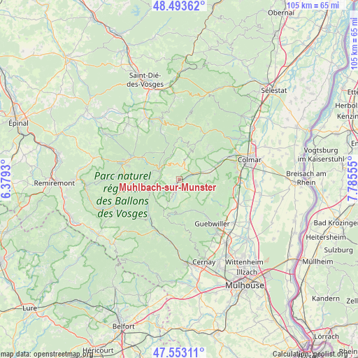
Muhlbach-sur-Munster GPS coordinates[2]
48° 1' 31.836" North, 7° 4' 56.748" East
| Map corner | latitude | longitude |
|---|---|---|
| Upper-left | 48.49362°, | 6.3793° |
| Center: | 48.02551°, | 7.08243° |
| Lower-right: | 47.55311°, | 7.78555° |
| Map W x H: | 104.6×104.6 km | = 65×65mi |
| max Lat: | 51.07786° ⇑40.3% North |
| Muhlbach-sur-Munster: | 48.02551° |
| min Lat: | ⇓59.7% South 41.3874° |
| min Long | Muhlbach-sur-Mu | max Long |
| -5.08615° | 7.08243° | 9.52242° |
| W 95.1%⇐ | ⇒4.9% E |
Elevation
Elevation of Muhlbach-sur-Munster is 531 m = 1742 ft, and this is 337.3 m = 1107 ft above average elevation for this country.
| Max E: |
2333 m = 7654 ft | 6.3% |
| Muhlbach-sur-Munster | 531 m 1742 ft | |
| Avg. | 193.7 m = 635 ft | |
Min E: |
-1 m = -3 ft | 93.7% |
See also: France elevation on elevation.city.
Geographical zone
Muhlbach-sur-Munster is located in North temperate zone (between Tropic of Cancer and the Arctic Circle). Distance of this North polar circle is 2061.2 km =1280.8 mi to North.| Distance of | km | miles | from Muhlbach-sur-Munster |
|---|---|---|---|
| North Pole | 4667.1 | 2900 | to North |
| Arctic Circle | 2061.2 | 1280.8 | to North |
| Tropic Cancer | 2734 | 1698.8 | to South |
| Equator | 5339.9 | 3318.1 | to South |


Nearby cities:
15 places around Muhlbach-sur-Munster: (largest is in red/bold)
• Breitenbach-Haut-Rhin
1.5 km =0.9 mi,  99°
99°
• Griesbach-au-Val
6.8 km =4.2 mi,  80°
80°
• Gunsbach
7.4 km =4.6 mi,  70°
70°
• Lautenbach
11 km =6.8 mi,  149°
149°
• Lautenbachzell
10.5 km =6.5 mi, 153°
• Linthal
8.7 km =5.4 mi,  158°
158°
• Luttenbach-près-Munster
2.7 km =1.7 mi, 74°
• Metzeral
1.7 km =1.1 mi,  210°
210°
• Munster
4.5 km =2.8 mi, 68°
• Osenbach
11 km =6.8 mi,  113°
113°
• Sondernach
3.1 km =1.9 mi,  191°
191°
• Soultzbach-les-Bains
9.2 km =5.7 mi, 81°
• Soultzeren
4.5 km =2.8 mi,  19°
19°
• Stosswihr
3.4 km =2.1 mi, 22°
• Wihr-au-Val
9.6 km =6 mi, 72°
Sources, notices
• [Note1] Compared only with cities in France existing in our database
• [Src1] Map data: © OpenStreetMap contributors (CC-BY-SA)
• [Src2] Other city data from geonames.org with taken over terms of usage.
• [Src3] Geographical zone / Annual Mean Temperature by Robert A. Rohde @ Wikipedia
