Metzeral geodata
Metzeral (Grand Est) is a populated place; located in France in Europe/Paris (GMT+2) time zone. With population of 1,109 people, there are 8069 cities with bigger population in this country. Compared to other cities in France, 59.4% of cities are located further ↓South; 95.1% of cities are located further ←West and 94.7% of cities have lower elevation than Metzeral. Note1
Administrative division(s):
- Level 1: Grand Est
- Level 2: Haut-Rhin
- Level 3: Arrondissement de Colmar-Ribeauvillé
- Level 4: Metzeral


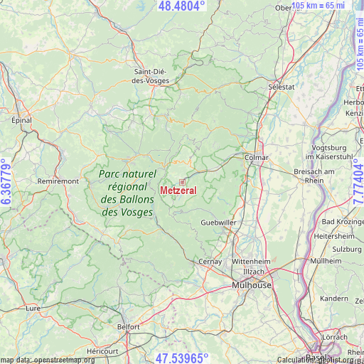
Metzeral GPS coordinates[2]
48° 0' 43.812" North, 7° 4' 15.276" East
| Map corner | latitude | longitude |
|---|---|---|
| Upper-left | 48.4804°, | 6.36779° |
| Center: | 48.01217°, | 7.07091° |
| Lower-right: | 47.53965°, | 7.77404° |
| Map W x H: | 104.6×104.6 km | = 65×65mi |
| max Lat: | 51.07786° ⇑40.6% North |
| Metzeral: | 48.01217° |
| min Lat: | ⇓59.4% South 41.3874° |
| min Long | Metzeral | max Long |
| -5.08615° | 7.07091° | 9.52242° |
| W 95.1%⇐ | ⇒4.9% E |
Elevation
Elevation of Metzeral is 568 m = 1864 ft, and this is 374.3 m = 1228 ft above average elevation for this country.
| Max E: |
2333 m = 7654 ft | 5.3% |
| Metzeral | 568 m 1864 ft | |
| Avg. | 193.7 m = 635 ft | |
Min E: |
-1 m = -3 ft | 94.7% |
See also: France elevation on elevation.city.
Geographical zone
Metzeral is located in North temperate zone (between Tropic of Cancer and the Arctic Circle). Distance of this North polar circle is 2062.7 km =1281.7 mi to North.| Distance of | km | miles | from Metzeral |
|---|---|---|---|
| North Pole | 4668.6 | 2900.9 | to North |
| Arctic Circle | 2062.7 | 1281.7 | to North |
| Tropic Cancer | 2732.5 | 1697.9 | to South |
| Equator | 5338.5 | 3317.2 | to South |


Nearby cities:
15 places around Metzeral: (largest is in red/bold)
• Breitenbach-Haut-Rhin
2.6 km =1.6 mi,  61°
61°
• Griesbach-au-Val
8 km =5 mi,  70°
70°
• Gunsbach
8.8 km =5.5 mi, 63°
• Lautenbach
10.3 km =6.4 mi,  140°
140°
• Lautenbachzell
9.7 km =6 mi, 144°
• Linthal
7.8 km =4.8 mi,  148°
148°
• Luttenbach-près-Munster
4.1 km =2.5 mi, 57°
• Muhlbach-sur-Munster
1.7 km =1.1 mi,  30°
30°
• Munster
6 km =3.7 mi, 58°
• Osenbach
11.3 km =7 mi,  104°
104°
• Sondernach
1.6 km =1 mi,  171°
171°
• Soultzbach-les-Bains
10.3 km =6.4 mi, 74°
• Soultzeren
6.2 km =3.9 mi,  22°
22°
• Stosswihr
5.1 km =3.2 mi, 24°
• Wihr-au-Val
10.9 km =6.8 mi, 66°
Sources, notices
• [Note1] Compared only with cities in France existing in our database
• [Src1] Map data: © OpenStreetMap contributors (CC-BY-SA)
• [Src2] Other city data from geonames.org with taken over terms of usage.
• [Src3] Geographical zone / Annual Mean Temperature by Robert A. Rohde @ Wikipedia
