Moustoir-Ac geodata
Moustoir-Ac (Brittany) is a populated place; located in France in Europe/Paris (GMT+2) time zone. With population of 1,520 people, there are 6121 cities with bigger population in this country. Compared to other cities in France, 56.7% of cities are located further ↓South; 96.9% of cities are located further →East and 54.4% of cities have higher elevation than Moustoir-Ac. Note1
Administrative division(s):
- Level 1: Brittany
- Level 2: Morbihan
- Level 3: Arrondissement de Pontivy
- Level 4: Moustoir-Ac


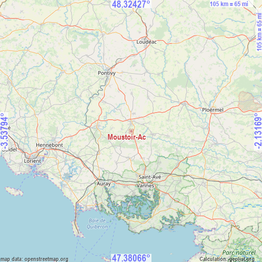
Moustoir-Ac GPS coordinates[2]
47° 51' 16.596" North, 2° 50' 5.316" West
| Map corner | latitude | longitude |
|---|---|---|
| Upper-left | 48.32427°, | -3.53794° |
| Center: | 47.85461°, | -2.83481° |
| Lower-right: | 47.38066°, | -2.13169° |
| Map W x H: | 104.9×104.9 km | = 65.2×65.2mi |
| max Lat: | 51.07786° ⇑43.3% North |
| Moustoir-Ac: | 47.85461° |
| min Lat: | ⇓56.7% South 41.3874° |
| min Long | Moustoir-Ac | max Long |
| -5.08615° | -2.83481° | 9.52242° |
| W 3.1%⇐ | ⇒96.9% E |
Elevation
Elevation of Moustoir-Ac is 118 m = 387 ft, and this is 75.7 m = 248 ft below average elevation for this country.
| Max E: |
2333 m = 7654 ft | 54.4% |
| Avg. | 193.7 m = 635 ft | |
| Moustoir-Ac | 118 m = 387 ft | |
Min E: |
-1 m = -3 ft | 45.6% |
See also: France elevation on elevation.city.
Geographical zone
Moustoir-Ac is located in North temperate zone (between Tropic of Cancer and the Arctic Circle). Distance of this North polar circle is 2080.2 km =1292.6 mi to North.| Distance of | km | miles | from Moustoir-Ac |
|---|---|---|---|
| North Pole | 4686.1 | 2911.8 | to North |
| Arctic Circle | 2080.2 | 1292.6 | to North |
| Tropic Cancer | 2715 | 1687 | to South |
| Equator | 5320.9 | 3306.3 | to South |


Nearby cities:
15 places around Moustoir-Ac: (largest is in red/bold)
• Bignan
5.5 km =3.4 mi,  59°
59°
• Brandivy
12.2 km =7.6 mi,  222°
222°
• Camors
12.3 km =7.6 mi,  266°
266°
• Colpo
4.5 km =2.8 mi,  155°
155°
• Grand-Champ
10.8 km =6.7 mi,  184°
184°
• Guénin
12.3 km =7.6 mi,  298°
298°
• La Chapelle-Neuve
7.9 km =4.9 mi,  277°
277°
• Locmaria-Grand-Champ
11.5 km =7.1 mi, 161°
• Locminé
3.5 km =2.2 mi,  359°
359°
• Moréac
7.3 km =4.5 mi,  9°
9°
• Plaudren
13.5 km =8.4 mi,  128°
128°
• Plumelin
4 km =2.5 mi, 279°
• Remungol
9.8 km =6.1 mi,  332°
332°
• Saint-Allouestre
7.8 km =4.8 mi, 332°
• Saint-Jean-Brévelay
8.5 km =5.3 mi,  97°
97°
Sources, notices
• [Note1] Compared only with cities in France existing in our database
• [Src1] Map data: © OpenStreetMap contributors (CC-BY-SA)
• [Src2] Other city data from geonames.org with taken over terms of usage.
• [Src3] Geographical zone / Annual Mean Temperature by Robert A. Rohde @ Wikipedia
