Colpo geodata
Colpo (Brittany) is a populated place; located in France in Europe/Paris (GMT+2) time zone. With population of 1,922 people, there are 4987 cities with bigger population in this country. Compared to other cities in France, 56.1% of cities are located further ↓South; 96.8% of cities are located further →East and 59.1% of cities have higher elevation than Colpo. Note1
Administrative division(s):
- Level 1: Brittany
- Level 2: Morbihan
- Level 3: Arrondissement de Vannes
- Level 4: Colpo


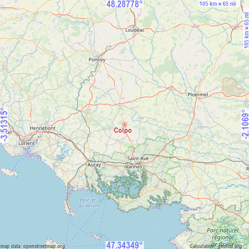
Colpo GPS coordinates[2]
47° 49' 4.008" North, 2° 48' 36.072" West
| Map corner | latitude | longitude |
|---|---|---|
| Upper-left | 48.28778°, | -3.51315° |
| Center: | 47.81778°, | -2.81002° |
| Lower-right: | 47.34349°, | -2.1069° |
| Map W x H: | 105×105 km | = 65.2×65.2mi |
| max Lat: | 51.07786° ⇑43.9% North |
| Colpo: | 47.81778° |
| min Lat: | ⇓56.1% South 41.3874° |
| min Long | Colpo | max Long |
| -5.08615° | -2.81002° | 9.52242° |
| W 3.2%⇐ | ⇒96.8% E |
Elevation
Elevation of Colpo is 105 m = 344 ft, and this is 88.7 m = 291 ft below average elevation for this country.
| Max E: |
2333 m = 7654 ft | 59.1% |
| Avg. | 193.7 m = 635 ft | |
| Colpo | 105 m = 344 ft | |
Min E: |
-1 m = -3 ft | 40.9% |
See also: France elevation on elevation.city.
Geographical zone
Colpo is located in North temperate zone (between Tropic of Cancer and the Arctic Circle). Distance of this North polar circle is 2084.3 km =1295.1 mi to North.| Distance of | km | miles | from Colpo |
|---|---|---|---|
| North Pole | 4690.2 | 2914.4 | to North |
| Arctic Circle | 2084.3 | 1295.1 | to North |
| Tropic Cancer | 2710.9 | 1684.5 | to South |
| Equator | 5316.8 | 3303.7 | to South |


Nearby cities:
15 places around Colpo: (largest is in red/bold)
• Bignan
7.4 km =4.6 mi,  22°
22°
• Brandivy
11.2 km =7 mi,  243°
243°
• Grand-Champ
7.2 km =4.5 mi,  202°
202°
• La Chapelle-Neuve
11 km =6.8 mi,  297°
297°
• Locmaria-Grand-Champ
7 km =4.3 mi,  165°
165°
• Locminé
7.8 km =4.8 mi,  346°
346°
• Meucon
11.8 km =7.3 mi,  162°
162°
• Moréac
11.4 km =7.1 mi,  356°
356°
• Moustoir-Ac
4.5 km =2.8 mi,  335°
335°
• Plaudren
9.7 km =6 mi,  116°
116°
• Plumelec
12.9 km =8 mi,  80°
80°
• Plumelin
7.5 km =4.7 mi,  309°
309°
• Plumergat
11.6 km =7.2 mi,  222°
222°
• Saint-Allouestre
12.3 km =7.6 mi,  333°
333°
• Saint-Jean-Brévelay
7.2 km =4.5 mi,  65°
65°
Sources, notices
• [Note1] Compared only with cities in France existing in our database
• [Src1] Map data: © OpenStreetMap contributors (CC-BY-SA)
• [Src2] Other city data from geonames.org with taken over terms of usage.
• [Src3] Geographical zone / Annual Mean Temperature by Robert A. Rohde @ Wikipedia
