Moussey geodata
Moussey (Grand Est) is a populated place; located in France in Europe/Paris (GMT+2) time zone. With population of 606 people, there are 13224 cities with bigger population in this country. Compared to other cities in France, 72.6% of cities are located further ↓South; 93.5% of cities are located further ←West and 74.4% of cities have lower elevation than Moussey. Note1
Administrative division(s):
- Level 1: Grand Est
- Level 2: Moselle
- Level 3: Arrondissement de Sarrebourg-Château-Salins
- Level 4: Moussey


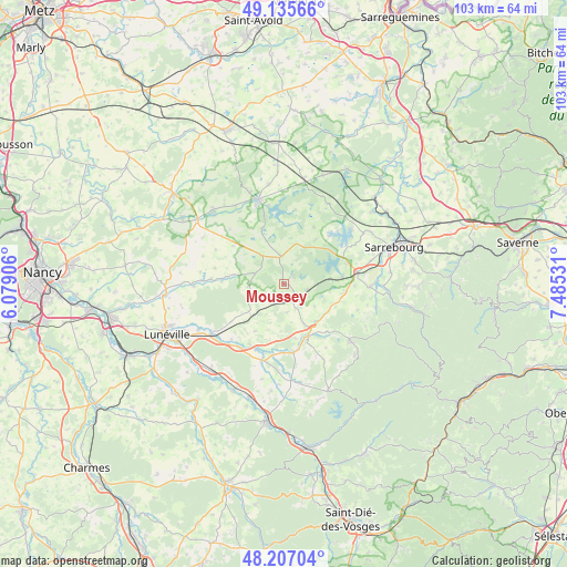
Moussey GPS coordinates[2]
48° 40' 24.564" North, 6° 46' 55.848" East
| Map corner | latitude | longitude |
|---|---|---|
| Upper-left | 49.13566°, | 6.07906° |
| Center: | 48.67349°, | 6.78218° |
| Lower-right: | 48.20704°, | 7.48531° |
| Map W x H: | 103.3×103.3 km | = 64.2×64.2mi |
| max Lat: | 51.07786° ⇑27.4% North |
| Moussey: | 48.67349° |
| min Lat: | ⇓72.6% South 41.3874° |
| min Long | Moussey | max Long |
| -5.08615° | 6.78218° | 9.52242° |
| W 93.5%⇐ | ⇒6.5% E |
Elevation
Elevation of Moussey is 245 m = 804 ft, and this is 51.3 m = 168 ft above average elevation for this country.
| Max E: |
2333 m = 7654 ft | 25.6% |
| Moussey | 245 m 804 ft | |
| Avg. | 193.7 m = 635 ft | |
Min E: |
-1 m = -3 ft | 74.4% |
See also: France elevation on elevation.city.
Geographical zone
Moussey is located in North temperate zone (between Tropic of Cancer and the Arctic Circle). Distance of this North polar circle is 1989.2 km =1236 mi to North.| Distance of | km | miles | from Moussey |
|---|---|---|---|
| North Pole | 4595.1 | 2855.3 | to North |
| Arctic Circle | 1989.2 | 1236 | to North |
| Tropic Cancer | 2806.1 | 1743.6 | to South |
| Equator | 5412 | 3362.9 | to South |


Nearby cities:
15 places around Moussey: (largest is in red/bold)
• Avricourt
2.9 km =1.8 mi,  153°
153°
• Bénaménil
14.1 km =8.8 mi,  215°
215°
• Chanteheux
20.5 km =12.7 mi,  245°
245°
• Chenevières
20.5 km =12.7 mi,  213°
213°
• Cirey-sur-Vezouze
15.8 km =9.8 mi,  130°
130°
• Croismare
17.7 km =11 mi,  241°
241°
• Dieuze
16.2 km =10.1 mi,  343°
343°
• Hesse
19.7 km =12.2 mi,  83°
83°
• Imling
18.4 km =11.4 mi,  73°
73°
• Lorquin
15.9 km =9.9 mi,  90°
90°
• Marainviller
16.3 km =10.1 mi,  234°
234°
• Nitting
18.2 km =11.3 mi, 90°
• Réchicourt-le-Château
4.3 km =2.7 mi,  102°
102°
• Saint-Clément
20.6 km =12.8 mi, 219°
• Vergaville
18.5 km =11.5 mi,  351°
351°
Sources, notices
• [Note1] Compared only with cities in France existing in our database
• [Src1] Map data: © OpenStreetMap contributors (CC-BY-SA)
• [Src2] Other city data from geonames.org with taken over terms of usage.
• [Src3] Geographical zone / Annual Mean Temperature by Robert A. Rohde @ Wikipedia
