Juigné geodata
Juigné (Pays de la Loire) is a populated place; located in France in Europe/Paris (GMT+2) time zone. With population of 7,007 people, there are 1397 cities with bigger population in this country. Compared to other cities in France, 54.5% of cities are located further ↓South; 82% of cities are located further →East and 88.3% of cities have higher elevation than Juigné. Note1
Administrative division(s):
- Level 1: Pays de la Loire
- Level 2: Département de Maine-et-Loire
- Level 3: Angers
- Level 4: Morannes sur Sarthe-Daumeray


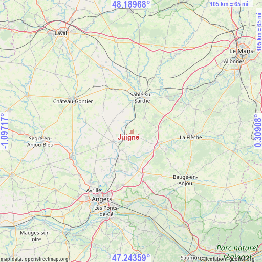
Juigné GPS coordinates[2]
47° 43' 7.608" North, 0° 23' 38.58" West
| Map corner | latitude | longitude |
|---|---|---|
| Upper-left | 48.18968°, | -1.09717° |
| Center: | 47.71878°, | -0.39405° |
| Lower-right: | 47.24359°, | 0.30908° |
| Map W x H: | 105.2×105.2 km | = 65.4×65.4mi |
| max Lat: | 51.07786° ⇑45.5% North |
| Juigné: | 47.71878° |
| min Lat: | ⇓54.5% South 41.3874° |
| min Long | Juigné | max Long |
| -5.08615° | -0.39405° | 9.52242° |
| W 18%⇐ | ⇒82% E |
Elevation
Elevation of Juigné is 34 m = 112 ft, and this is 159.7 m = 524 ft below average elevation for this country.
| Max E: |
2333 m = 7654 ft | 88.3% |
| Avg. | 193.7 m = 635 ft | |
| Juigné | 34 m = 112 ft | |
Min E: |
-1 m = -3 ft | 11.7% |
See also: France elevation on elevation.city.
Geographical zone
Juigné is located in North temperate zone (between Tropic of Cancer and the Arctic Circle). Distance of this North polar circle is 2095.3 km =1302 mi to North.| Distance of | km | miles | from Juigné |
|---|---|---|---|
| North Pole | 4701.2 | 2921.2 | to North |
| Arctic Circle | 2095.3 | 1302 | to North |
| Tropic Cancer | 2699.9 | 1677.6 | to South |
| Equator | 5305.8 | 3296.9 | to South |


Nearby cities:
15 places around Juigné: (largest is in red/bold)
• Brissarthe
4.6 km =2.9 mi,  243°
243°
• Châteauneuf-sur-Sarthe
8.1 km =5 mi, 239°
• Contigné
9.3 km =5.8 mi,  277°
277°
• Courtillers
11.4 km =7.1 mi,  37°
37°
• Daumeray
3.2 km =2 mi,  129°
129°
• Durtal
13 km =8.1 mi,  113°
113°
• Juvardeil
10.6 km =6.6 mi,  227°
227°
• Louailles
13.4 km =8.3 mi,  52°
52°
• Lézigné
11.7 km =7.3 mi,  141°
141°
• Miré
8.5 km =5.3 mi,  300°
300°
• Morannes
3.2 km =2 mi,  329°
329°
• Précigné
7.4 km =4.6 mi, 44°
• Souvigné-sur-Sarthe
12 km =7.5 mi,  1°
1°
• Tiercé
12.7 km =7.9 mi,  205°
205°
• Étriché
8.4 km =5.2 mi, 206°
Sources, notices
• [Note1] Compared only with cities in France existing in our database
• [Src1] Map data: © OpenStreetMap contributors (CC-BY-SA)
• [Src2] Other city data from geonames.org with taken over terms of usage.
• [Src3] Geographical zone / Annual Mean Temperature by Robert A. Rohde @ Wikipedia
