Montricoux geodata
Montricoux (Occitanie) is a populated place; located in France in Europe/Paris (GMT+2) time zone. With population of 1,044 people, there are 8506 cities with bigger population in this country. Compared to other cities in France, 86.5% of cities are located further ↑North; 61.4% of cities are located further →East and 53.3% of cities have higher elevation than Montricoux. Note1
Administrative division(s):
- Level 1: Occitanie
- Level 2: Département du Tarn-et-Garonne
- Level 3: Arrondissement de Montauban
- Level 4: Montricoux


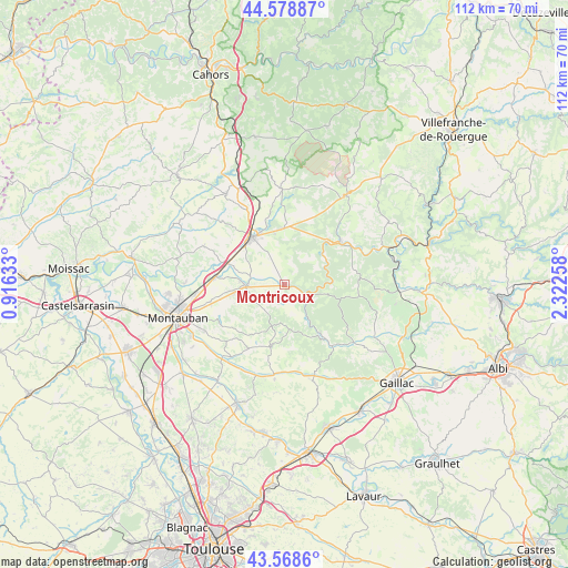
Montricoux GPS coordinates[2]
44° 4' 33.204" North, 1° 37' 10.056" East
| Map corner | latitude | longitude |
|---|---|---|
| Upper-left | 44.57887°, | 0.91633° |
| Center: | 44.07589°, | 1.61946° |
| Lower-right: | 43.5686°, | 2.32258° |
| Map W x H: | 112.3×112.3 km | = 69.8×69.8mi |
| max Lat: | 51.07786° ⇑86.5% North |
| Montricoux: | 44.07589° |
| min Lat: | ⇓13.5% South 41.3874° |
| min Long | Montricoux | max Long |
| -5.08615° | 1.61946° | 9.52242° |
| W 38.6%⇐ | ⇒61.4% E |
Elevation
Elevation of Montricoux is 121 m = 397 ft, and this is 72.7 m = 239 ft below average elevation for this country.
| Max E: |
2333 m = 7654 ft | 53.3% |
| Avg. | 193.7 m = 635 ft | |
| Montricoux | 121 m = 397 ft | |
Min E: |
-1 m = -3 ft | 46.7% |
See also: France elevation on elevation.city.
Geographical zone
Montricoux is located in North temperate zone (between Tropic of Cancer and the Arctic Circle). Distance of this Northern Tropic circle is 2294.9 km =1426 mi to South.| Distance of | km | miles | from Montricoux |
|---|---|---|---|
| North Pole | 5106.3 | 3172.9 | to North |
| Arctic Circle | 2500.4 | 1553.7 | to North |
| Tropic Cancer | 2294.9 | 1426 | to South |
| Equator | 4900.8 | 3045.2 | to South |


Nearby cities:
15 places around Montricoux: (largest is in red/bold)
• Albias
13.8 km =8.6 mi,  276°
276°
• Bioule
6.6 km =4.1 mi, 283°
• Bruniquel
4.3 km =2.7 mi,  123°
123°
• Caussade
11.4 km =7.1 mi,  325°
325°
• La Salvetat-Belmontet
14.2 km =8.8 mi,  209°
209°
• Léojac
15.1 km =9.4 mi,  244°
244°
• Mirabel
17.5 km =10.9 mi,  295°
295°
• Monclar-de-Quercy
12.6 km =7.8 mi,  192°
192°
• Monteils
10.9 km =6.8 mi,  341°
341°
• Nègrepelisse
8 km =5 mi,  268°
268°
• Penne
8.9 km =5.5 mi,  89°
89°
• Réalville
11.9 km =7.4 mi,  291°
291°
• Saint-Etienne-de-Tulmont
12.5 km =7.8 mi,  256°
256°
• Septfonds
11.4 km =7.1 mi,  359°
359°
• Vaïssac
6.3 km =3.9 mi,  221°
221°
Sources, notices
• [Note1] Compared only with cities in France existing in our database
• [Src1] Map data: © OpenStreetMap contributors (CC-BY-SA)
• [Src2] Other city data from geonames.org with taken over terms of usage.
• [Src3] Geographical zone / Annual Mean Temperature by Robert A. Rohde @ Wikipedia
