Bruniquel geodata
Bruniquel (Occitanie) is a populated place; located in France in Europe/Paris (GMT+2) time zone. With population of 598 people, there are 13354 cities with bigger population in this country. Compared to other cities in France, 86.6% of cities are located further ↑North; 60.8% of cities are located further →East and 55.3% of cities have lower elevation than Bruniquel. Note1
Administrative division(s):
- Level 1: Occitanie
- Level 2: Département du Tarn-et-Garonne
- Level 3: Arrondissement de Montauban
- Level 4: Bruniquel


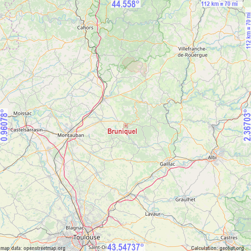
Bruniquel GPS coordinates[2]
44° 3' 17.424" North, 1° 39' 50.076" East
| Map corner | latitude | longitude |
|---|---|---|
| Upper-left | 44.558°, | 0.96078° |
| Center: | 44.05484°, | 1.66391° |
| Lower-right: | 43.54737°, | 2.36703° |
| Map W x H: | 112.4×112.4 km | = 69.8×69.8mi |
| max Lat: | 51.07786° ⇑86.6% North |
| Bruniquel: | 44.05484° |
| min Lat: | ⇓13.4% South 41.3874° |
| min Long | Bruniquel | max Long |
| -5.08615° | 1.66391° | 9.52242° |
| W 39.2%⇐ | ⇒60.8% E |
Elevation
Elevation of Bruniquel is 151 m = 495 ft, and this is 42.7 m = 140 ft below average elevation for this country.
| Max E: |
2333 m = 7654 ft | 44.7% |
| Avg. | 193.7 m = 635 ft | |
| Bruniquel | 151 m = 495 ft | |
Min E: |
-1 m = -3 ft | 55.3% |
See also: France elevation on elevation.city.
Geographical zone
Bruniquel is located in North temperate zone (between Tropic of Cancer and the Arctic Circle). Distance of this Northern Tropic circle is 2292.5 km =1424.5 mi to South.| Distance of | km | miles | from Bruniquel |
|---|---|---|---|
| North Pole | 5108.6 | 3174.3 | to North |
| Arctic Circle | 2502.7 | 1555.1 | to North |
| Tropic Cancer | 2292.5 | 1424.5 | to South |
| Equator | 4898.4 | 3043.7 | to South |


Nearby cities:
15 places around Bruniquel: (largest is in red/bold)
• Bioule
10.7 km =6.6 mi,  291°
291°
• Castelnau-de-Montmiral
15.9 km =9.9 mi,  128°
128°
• Caussade
15.4 km =9.6 mi,  319°
319°
• La Salvetat-Belmontet
14.5 km =9 mi,  226°
226°
• Léojac
17.6 km =10.9 mi,  256°
256°
• Monclar-de-Quercy
11.7 km =7.3 mi,  212°
212°
• Monteils
14.5 km =9 mi,  331°
331°
• Montricoux
4.3 km =2.7 mi,  303°
303°
• Nègrepelisse
11.7 km =7.3 mi,  280°
280°
• Penne
5.9 km =3.7 mi,  65°
65°
• Réalville
16.1 km =10 mi, 294°
• Saint-Etienne-de-Tulmont
15.8 km =9.8 mi,  268°
268°
• Salvagnac
16.7 km =10.4 mi,  173°
173°
• Septfonds
14.2 km =8.8 mi,  345°
345°
• Vaïssac
8.1 km =5 mi,  252°
252°
Sources, notices
• [Note1] Compared only with cities in France existing in our database
• [Src1] Map data: © OpenStreetMap contributors (CC-BY-SA)
• [Src2] Other city data from geonames.org with taken over terms of usage.
• [Src3] Geographical zone / Annual Mean Temperature by Robert A. Rohde @ Wikipedia
