Albias geodata
Albias (Occitanie) is a populated place; located in France in Europe/Paris (GMT+2) time zone. With population of 2,528 people, there are 3859 cities with bigger population in this country. Compared to other cities in France, 86.3% of cities are located further ↑North; 63.7% of cities are located further →East and 64.4% of cities have higher elevation than Albias. Note1
Administrative division(s):
- Level 1: Occitanie
- Level 2: Département du Tarn-et-Garonne
- Level 3: Arrondissement de Montauban
- Level 4: Albias


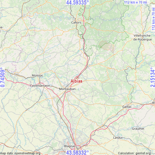
Albias GPS coordinates[2]
44° 5' 25.764" North, 1° 26' 53.556" East
| Map corner | latitude | longitude |
|---|---|---|
| Upper-left | 44.59335°, | 0.74509° |
| Center: | 44.09049°, | 1.44821° |
| Lower-right: | 43.58332°, | 2.15134° |
| Map W x H: | 112.3×112.3 km | = 69.8×69.8mi |
| max Lat: | 51.07786° ⇑86.3% North |
| Albias: | 44.09049° |
| min Lat: | ⇓13.7% South 41.3874° |
| min Long | Albias | max Long |
| -5.08615° | 1.44821° | 9.52242° |
| W 36.3%⇐ | ⇒63.7% E |
Elevation
Elevation of Albias is 91 m = 299 ft, and this is 102.7 m = 337 ft below average elevation for this country.
| Max E: |
2333 m = 7654 ft | 64.4% |
| Avg. | 193.7 m = 635 ft | |
| Albias | 91 m = 299 ft | |
Min E: |
-1 m = -3 ft | 35.6% |
See also: France elevation on elevation.city.
Geographical zone
Albias is located in North temperate zone (between Tropic of Cancer and the Arctic Circle). Distance of this Northern Tropic circle is 2296.5 km =1427 mi to South.| Distance of | km | miles | from Albias |
|---|---|---|---|
| North Pole | 5104.7 | 3171.9 | to North |
| Arctic Circle | 2498.8 | 1552.7 | to North |
| Tropic Cancer | 2296.5 | 1427 | to South |
| Equator | 4902.4 | 3046.2 | to South |


Nearby cities:
15 places around Albias: (largest is in red/bold)
• Bioule
7.2 km =4.5 mi,  90°
90°
• Caussade
10.7 km =6.6 mi,  42°
42°
• Lamothe-Capdeville
6.1 km =3.8 mi,  257°
257°
• Léojac
8.2 km =5.1 mi,  179°
179°
• Mirabel
6.3 km =3.9 mi,  339°
339°
• Molières
13.3 km =8.3 mi,  329°
329°
• Montalzat
13.7 km =8.5 mi,  17°
17°
• Montauban
10.5 km =6.5 mi,  219°
219°
• Monteils
13.4 km =8.3 mi,  49°
49°
• Nègrepelisse
6 km =3.7 mi,  107°
107°
• Puycornet
11.2 km =7 mi,  314°
314°
• Réalville
3.7 km =2.3 mi, 43°
• Saint-Etienne-de-Tulmont
4.7 km =2.9 mi,  161°
161°
• Vaïssac
11.4 km =7.1 mi,  123°
123°
• Villemade
12.8 km =8 mi, 262°
Sources, notices
• [Note1] Compared only with cities in France existing in our database
• [Src1] Map data: © OpenStreetMap contributors (CC-BY-SA)
• [Src2] Other city data from geonames.org with taken over terms of usage.
• [Src3] Geographical zone / Annual Mean Temperature by Robert A. Rohde @ Wikipedia
