Montoire-sur-le-Loir geodata
Montoire-sur-le-Loir (Centre) is a populated place; located in France in Europe/Paris (GMT+2) time zone. With population of 4,177 people, there are 2352 cities with bigger population in this country. Compared to other cities in France, 55.1% of cities are located further ↓South; 70% of cities are located further →East and 74.6% of cities have higher elevation than Montoire-sur-le-Loir. Note1
Administrative division(s):
- Level 1: Centre
- Level 2: Département du Loir-et-Cher
- Level 3: Arrondissement de Vendôme
- Level 4: Montoire-sur-le-Loir


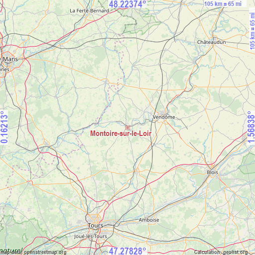
Montoire-sur-le-Loir GPS coordinates[2]
47° 45' 11.376" North, 0° 51' 54.9" East
| Map corner | latitude | longitude |
|---|---|---|
| Upper-left | 48.22374°, | 0.16213° |
| Center: | 47.75316°, | 0.86525° |
| Lower-right: | 47.27828°, | 1.56838° |
| Map W x H: | 105.1×105.1 km | = 65.3×65.3mi |
| max Lat: | 51.07786° ⇑44.9% North |
| Montoire-sur-le-Loir: | 47.75316° |
| min Lat: | ⇓55.1% South 41.3874° |
| min Long | Montoire-sur-le | max Long |
| -5.08615° | 0.86525° | 9.52242° |
| W 30%⇐ | ⇒70% E |
Elevation
Elevation of Montoire-sur-le-Loir is 68 m = 223 ft, and this is 125.7 m = 412 ft below average elevation for this country.
| Max E: |
2333 m = 7654 ft | 74.6% |
| Avg. | 193.7 m = 635 ft | |
| Montoire-sur-le-Loir | 68 m = 223 ft | |
Min E: |
-1 m = -3 ft | 25.4% |
See also: France elevation on elevation.city.
Geographical zone
Montoire-sur-le-Loir is located in North temperate zone (between Tropic of Cancer and the Arctic Circle). Distance of this North polar circle is 2091.5 km =1299.6 mi to North.| Distance of | km | miles | from Montoire-sur-le-Loir |
|---|---|---|---|
| North Pole | 4697.4 | 2918.8 | to North |
| Arctic Circle | 2091.5 | 1299.6 | to North |
| Tropic Cancer | 2703.7 | 1680 | to South |
| Equator | 5309.7 | 3299.3 | to South |


Nearby cities:
15 places around Montoire-sur-le-Loir: (largest is in red/bold)
• Authon
12.3 km =7.6 mi,  169°
169°
• Bessé-sur-Braye
12.4 km =7.7 mi,  315°
315°
• La Chapelle-Huon
14.6 km =9.1 mi, 322°
• Les Hermites
12.9 km =8 mi,  220°
220°
• Lunay
7.2 km =4.5 mi,  31°
31°
• Mazangé
9.9 km =6.2 mi,  37°
37°
• Monthodon
11.7 km =7.3 mi,  190°
190°
• Naveil
13.3 km =8.3 mi,  69°
69°
• Prunay-Cassereau
7.6 km =4.7 mi,  147°
147°
• Saint-Amand-Longpré
13.7 km =8.5 mi,  124°
124°
• Saint-Martin-des-Bois
4.4 km =2.7 mi, 222°
• Savigny-sur-Braye
14.6 km =9.1 mi,  343°
343°
• Thoré-la-Rochette
8.3 km =5.2 mi,  62°
62°
• Villerable
12.4 km =7.7 mi,  87°
87°
• Villiers-sur-Loir
11.5 km =7.1 mi, 59°
Sources, notices
• [Note1] Compared only with cities in France existing in our database
• [Src1] Map data: © OpenStreetMap contributors (CC-BY-SA)
• [Src2] Other city data from geonames.org with taken over terms of usage.
• [Src3] Geographical zone / Annual Mean Temperature by Robert A. Rohde @ Wikipedia
