Piscop geodata
Piscop (Île-de-France) is a populated place; located in France in Europe/Paris (GMT+2) time zone. With population of 725 people, there are 11465 cities with bigger population in this country. Compared to other cities in France, 80% of cities are located further ↓South; 51.9% of cities are located further →East and 62.4% of cities have higher elevation than Piscop. Note1
Administrative division(s):
- Level 1: Île-de-France
- Level 2: Département du Val-d’Oise
- Level 3: Arrondissement de Sarcelles
- Level 4: Piscop


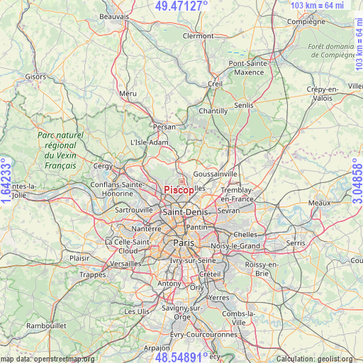
Piscop GPS coordinates[2]
49° 0' 44.028" North, 2° 20' 43.62" East
| Map corner | latitude | longitude |
|---|---|---|
| Upper-left | 49.47127°, | 1.64233° |
| Center: | 49.01223°, | 2.34545° |
| Lower-right: | 48.54891°, | 3.04858° |
| Map W x H: | 102.6×102.6 km | = 63.8×63.8mi |
| max Lat: | 51.07786° ⇑20% North |
| Piscop: | 49.01223° |
| min Lat: | ⇓80% South 41.3874° |
| min Long | Piscop | max Long |
| -5.08615° | 2.34545° | 9.52242° |
| W 48.1%⇐ | ⇒51.9% E |
Elevation
Elevation of Piscop is 96 m = 315 ft, and this is 97.7 m = 321 ft below average elevation for this country.
| Max E: |
2333 m = 7654 ft | 62.4% |
| Avg. | 193.7 m = 635 ft | |
| Piscop | 96 m = 315 ft | |
Min E: |
-1 m = -3 ft | 37.6% |
See also: France elevation on elevation.city.
Geographical zone
Piscop is located in North temperate zone (between Tropic of Cancer and the Arctic Circle). Distance of this North polar circle is 1951.5 km =1212.6 mi to North.| Distance of | km | miles | from Piscop |
|---|---|---|---|
| North Pole | 4557.4 | 2831.8 | to North |
| Arctic Circle | 1951.5 | 1212.6 | to North |
| Tropic Cancer | 2843.7 | 1767 | to South |
| Equator | 5449.6 | 3386.2 | to South |


Nearby cities:
15 places around Piscop: (largest is in red/bold)
• Andilly
3.2 km =2 mi,  264°
264°
• Deuil-la-Barre
4.2 km =2.6 mi,  198°
198°
• Domont
2.2 km =1.4 mi,  321°
321°
• Groslay
3 km =1.9 mi,  177°
177°
• Margency
3.6 km =2.2 mi,  247°
247°
• Moisselles
4.3 km =2.7 mi,  350°
350°
• Montlignon
4.3 km =2.7 mi, 261°
• Montmagny
4.3 km =2.7 mi, 178°
• Montmorency
2.7 km =1.7 mi, 183°
• Saint-Brice-sous-Forêt
1.4 km =0.9 mi,  153°
153°
• Sarcelles
2.9 km =1.8 mi,  124°
124°
• Soisy-sous-Montmorency
4.2 km =2.6 mi,  230°
230°
• Villiers-le-Bel
3.9 km =2.4 mi,  95°
95°
• Écouen
2.9 km =1.8 mi,  71°
71°
• Ézanville
2.4 km =1.5 mi,  43°
43°
Sources, notices
• [Note1] Compared only with cities in France existing in our database
• [Src1] Map data: © OpenStreetMap contributors (CC-BY-SA)
• [Src2] Other city data from geonames.org with taken over terms of usage.
• [Src3] Geographical zone / Annual Mean Temperature by Robert A. Rohde @ Wikipedia
