Montmorency geodata
Montmorency (Île-de-France) is a populated place; located in France in Europe/Paris (GMT+2) time zone. With population of 21,156 people, there are 429 cities with bigger population in this country. Compared to other cities in France, 79.4% of cities are located further ↓South; 52% of cities are located further →East and 74.6% of cities have higher elevation than Montmorency. Note1
Administrative division(s):
- Level 1: Île-de-France
- Level 2: Département du Val-d’Oise
- Level 3: Arrondissement de Sarcelles
- Level 4: Montmorency


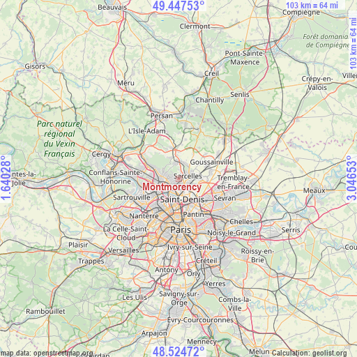
Montmorency GPS coordinates[2]
48° 59' 17.736" North, 2° 20' 36.24" East
| Map corner | latitude | longitude |
|---|---|---|
| Upper-left | 49.44753°, | 1.64028° |
| Center: | 48.98826°, | 2.3434° |
| Lower-right: | 48.52472°, | 3.04653° |
| Map W x H: | 102.6×102.6 km | = 63.8×63.8mi |
| max Lat: | 51.07786° ⇑20.6% North |
| Montmorency: | 48.98826° |
| min Lat: | ⇓79.4% South 41.3874° |
| min Long | Montmorency | max Long |
| -5.08615° | 2.3434° | 9.52242° |
| W 48%⇐ | ⇒52% E |
Elevation
Elevation of Montmorency is 68 m = 223 ft, and this is 125.7 m = 412 ft below average elevation for this country.
| Max E: |
2333 m = 7654 ft | 74.6% |
| Avg. | 193.7 m = 635 ft | |
| Montmorency | 68 m = 223 ft | |
Min E: |
-1 m = -3 ft | 25.4% |
See also: France elevation on elevation.city.
Geographical zone
Montmorency is located in North temperate zone (between Tropic of Cancer and the Arctic Circle). Distance of this North polar circle is 1954.2 km =1214.3 mi to North.| Distance of | km | miles | from Montmorency |
|---|---|---|---|
| North Pole | 4560.1 | 2833.5 | to North |
| Arctic Circle | 1954.2 | 1214.3 | to North |
| Tropic Cancer | 2841.1 | 1765.4 | to South |
| Equator | 5447 | 3384.6 | to South |


Nearby cities:
15 places around Montmorency: (largest is in red/bold)
• Andilly
3.8 km =2.4 mi,  308°
308°
• Deuil-la-Barre
1.7 km =1.1 mi,  222°
222°
• Enghien-les-Bains
3.1 km =1.9 mi, 219°
• Groslay
0.4 km =0.2 mi,  135°
135°
• Margency
3.4 km =2.1 mi,  292°
292°
• Montmagny
1.7 km =1.1 mi,  171°
171°
• Pierrefitte-sur-Seine
2.7 km =1.7 mi,  151°
151°
• Piscop
2.7 km =1.7 mi,  3°
3°
• Saint-Brice-sous-Forêt
1.6 km =1 mi,  27°
27°
• Saint-Gratien
4.4 km =2.7 mi,  248°
248°
• Sarcelles
2.7 km =1.7 mi,  68°
68°
• Soisy-sous-Montmorency
3.1 km =1.9 mi,  269°
269°
• Villetaneuse
3.3 km =2.1 mi,  182°
182°
• Écouen
4.6 km =2.9 mi,  38°
38°
• Épinay-sur-Seine
4.4 km =2.7 mi,  208°
208°
Sources, notices
• [Note1] Compared only with cities in France existing in our database
• [Src1] Map data: © OpenStreetMap contributors (CC-BY-SA)
• [Src2] Other city data from geonames.org with taken over terms of usage.
• [Src3] Geographical zone / Annual Mean Temperature by Robert A. Rohde @ Wikipedia
