Deuil-la-Barre geodata
Deuil-la-Barre (Île-de-France) is a populated place; located in France in Europe/Paris (GMT+2) time zone. With population of 21,560 people, there are 416 cities with bigger population in this country. Compared to other cities in France, 79.2% of cities are located further ↓South; 52.2% of cities are located further →East and 80.2% of cities have higher elevation than Deuil-la-Barre. Note1
Administrative division(s):
- Level 1: Île-de-France
- Level 2: Département du Val-d’Oise
- Level 3: Arrondissement de Sarcelles
- Level 4: Deuil-la-Barre


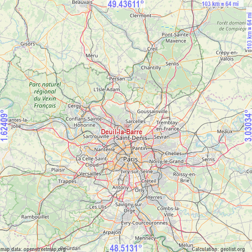
Deuil-la-Barre GPS coordinates[2]
48° 58' 36.264" North, 2° 19' 37.992" East
| Map corner | latitude | longitude |
|---|---|---|
| Upper-left | 49.43611°, | 1.62409° |
| Center: | 48.97674°, | 2.32722° |
| Lower-right: | 48.5131°, | 3.03034° |
| Map W x H: | 102.6×102.6 km | = 63.8×63.8mi |
| max Lat: | 51.07786° ⇑20.8% North |
| Deuil-la-Barre: | 48.97674° |
| min Lat: | ⇓79.2% South 41.3874° |
| min Long | Deuil-la-Barre | max Long |
| -5.08615° | 2.32722° | 9.52242° |
| W 47.8%⇐ | ⇒52.2% E |
Elevation
Elevation of Deuil-la-Barre is 54 m = 177 ft, and this is 139.7 m = 458 ft below average elevation for this country.
| Max E: |
2333 m = 7654 ft | 80.2% |
| Avg. | 193.7 m = 635 ft | |
| Deuil-la-Barre | 54 m = 177 ft | |
Min E: |
-1 m = -3 ft | 19.8% |
See also: France elevation on elevation.city.
Geographical zone
Deuil-la-Barre is located in North temperate zone (between Tropic of Cancer and the Arctic Circle). Distance of this North polar circle is 1955.5 km =1215.1 mi to North.| Distance of | km | miles | from Deuil-la-Barre |
|---|---|---|---|
| North Pole | 4561.4 | 2834.3 | to North |
| Arctic Circle | 1955.5 | 1215.1 | to North |
| Tropic Cancer | 2839.8 | 1764.6 | to South |
| Equator | 5445.7 | 3383.8 | to South |


Nearby cities:
15 places around Deuil-la-Barre: (largest is in red/bold)
• Andilly
4.1 km =2.5 mi,  333°
333°
• Eaubonne
4 km =2.5 mi,  304°
304°
• Enghien-les-Bains
1.4 km =0.9 mi,  214°
214°
• Groslay
1.8 km =1.1 mi,  56°
56°
• Margency
3.3 km =2.1 mi,  322°
322°
• Montmagny
1.5 km =0.9 mi,  104°
104°
• Montmorency
1.7 km =1.1 mi,  42°
42°
• Pierrefitte-sur-Seine
2.7 km =1.7 mi,  113°
113°
• Piscop
4.2 km =2.6 mi,  18°
18°
• Saint-Brice-sous-Forêt
3.3 km =2.1 mi, 35°
• Saint-Gratien
2.9 km =1.8 mi,  262°
262°
• Soisy-sous-Montmorency
2.3 km =1.4 mi, 304°
• Villeneuve-la-Garenne
4.3 km =2.7 mi,  192°
192°
• Villetaneuse
2.3 km =1.4 mi,  152°
152°
• Épinay-sur-Seine
2.7 km =1.7 mi,  198°
198°
Sources, notices
• [Note1] Compared only with cities in France existing in our database
• [Src1] Map data: © OpenStreetMap contributors (CC-BY-SA)
• [Src2] Other city data from geonames.org with taken over terms of usage.
• [Src3] Geographical zone / Annual Mean Temperature by Robert A. Rohde @ Wikipedia
