Escalquens geodata
Escalquens (Occitanie) is a populated place; located in France in Europe/Paris (GMT+2) time zone. With population of 6,162 people, there are 1609 cities with bigger population in this country. Compared to other cities in France, 92.8% of cities are located further ↑North; 62.3% of cities are located further →East and 60.3% of cities have lower elevation than Escalquens. Note1
Administrative division(s):
- Level 1: Occitanie
- Level 2: Haute-Garonne
- Level 3: Arrondissement de Toulouse
- Level 4: Escalquens


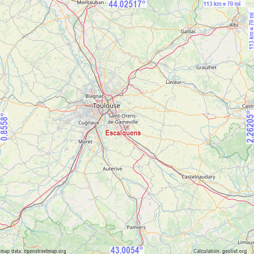
Escalquens GPS coordinates[2]
43° 31' 2.784" North, 1° 33' 32.148" East
| Map corner | latitude | longitude |
|---|---|---|
| Upper-left | 44.02517°, | 0.8558° |
| Center: | 43.51744°, | 1.55893° |
| Lower-right: | 43.0054°, | 2.26205° |
| Map W x H: | 113.4×113.4 km | = 70.5×70.5mi |
| max Lat: | 51.07786° ⇑92.8% North |
| Escalquens: | 43.51744° |
| min Lat: | ⇓7.2% South 41.3874° |
| min Long | Escalquens | max Long |
| -5.08615° | 1.55893° | 9.52242° |
| W 37.7%⇐ | ⇒62.3% E |
Elevation
Elevation of Escalquens is 171 m = 561 ft, and this is 22.7 m = 74 ft below average elevation for this country.
| Max E: |
2333 m = 7654 ft | 39.7% |
| Avg. | 193.7 m = 635 ft | |
| Escalquens | 171 m = 561 ft | |
Min E: |
-1 m = -3 ft | 60.3% |
See also: France elevation on elevation.city.
Geographical zone
Escalquens is located in North temperate zone (between Tropic of Cancer and the Arctic Circle). Distance of this Northern Tropic circle is 2232.8 km =1387.4 mi to South.| Distance of | km | miles | from Escalquens |
|---|---|---|---|
| North Pole | 5168.4 | 3211.5 | to North |
| Arctic Circle | 2562.5 | 1592.3 | to North |
| Tropic Cancer | 2232.8 | 1387.4 | to South |
| Equator | 4838.7 | 3006.6 | to South |


Nearby cities:
15 places around Escalquens: (largest is in red/bold)
• Aigrefeuille
6.2 km =3.9 mi,  24°
24°
• Auzielle
2.7 km =1.7 mi,  11°
11°
• Belberaud
1.5 km =0.9 mi,  153°
153°
• Castanet-Tolosan
4.9 km =3 mi,  267°
267°
• Deyme
4.8 km =3 mi,  214°
214°
• Donneville
5.2 km =3.2 mi,  189°
189°
• Fourquevaux
4.6 km =2.9 mi,  106°
106°
• Labège
2.3 km =1.4 mi,  307°
307°
• Lauzerville
4.3 km =2.7 mi, 6°
• Montgiscard
6.3 km =3.9 mi,  173°
173°
• Montlaur
3.2 km =2 mi, 166°
• Odars
2.5 km =1.6 mi,  76°
76°
• Pompertuzat
4.5 km =2.8 mi,  232°
232°
• Péchabou
4.3 km =2.7 mi,  247°
247°
• Saint-Orens-de-Gameville
4.5 km =2.8 mi,  333°
333°
Sources, notices
• [Note1] Compared only with cities in France existing in our database
• [Src1] Map data: © OpenStreetMap contributors (CC-BY-SA)
• [Src2] Other city data from geonames.org with taken over terms of usage.
• [Src3] Geographical zone / Annual Mean Temperature by Robert A. Rohde @ Wikipedia
