Péchabou geodata
Péchabou (Occitanie) is a populated place; located in France in Europe/Paris (GMT+2) time zone. With population of 1,461 people, there are 6329 cities with bigger population in this country. Compared to other cities in France, 93% of cities are located further ↑North; 62.9% of cities are located further →East and 63.3% of cities have lower elevation than Péchabou. Note1
Administrative division(s):
- Level 1: Occitanie
- Level 2: Haute-Garonne
- Level 3: Arrondissement de Toulouse
- Level 4: Péchabou


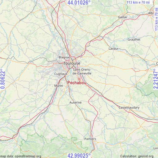
Péchabou GPS coordinates[2]
43° 30' 8.676" North, 1° 30' 33.624" East
| Map corner | latitude | longitude |
|---|---|---|
| Upper-left | 44.01026°, | 0.80622° |
| Center: | 43.50241°, | 1.50934° |
| Lower-right: | 42.99025°, | 2.21247° |
| Map W x H: | 113.4×113.4 km | = 70.5×70.5mi |
| max Lat: | 51.07786° ⇑93% North |
| Péchabou: | 43.50241° |
| min Lat: | ⇓7% South 41.3874° |
| min Long | Péchabou | max Long |
| -5.08615° | 1.50934° | 9.52242° |
| W 37.1%⇐ | ⇒62.9% E |
Elevation
Elevation of Péchabou is 186 m = 610 ft, and this is 7.7 m = 25 ft below average elevation for this country.
| Max E: |
2333 m = 7654 ft | 36.7% |
| Avg. | 193.7 m = 635 ft | |
| Péchabou | 186 m = 610 ft | |
Min E: |
-1 m = -3 ft | 63.3% |
See also: France elevation on elevation.city.
Geographical zone
Péchabou is located in North temperate zone (between Tropic of Cancer and the Arctic Circle). Distance of this Northern Tropic circle is 2231.1 km =1386.3 mi to South.| Distance of | km | miles | from Péchabou |
|---|---|---|---|
| North Pole | 5170 | 3212.5 | to North |
| Arctic Circle | 2564.2 | 1593.3 | to North |
| Tropic Cancer | 2231.1 | 1386.3 | to South |
| Equator | 4837 | 3005.6 | to South |


Nearby cities:
15 places around Péchabou: (largest is in red/bold)
• Aureville
5.2 km =3.2 mi,  243°
243°
• Auzeville-Tolosane
3.6 km =2.2 mi,  322°
322°
• Belberaud
4.7 km =2.9 mi,  85°
85°
• Castanet-Tolosan
1.7 km =1.1 mi,  330°
330°
• Corronsac
3.3 km =2.1 mi,  196°
196°
• Deyme
2.6 km =1.6 mi,  150°
150°
• Donneville
4.7 km =2.9 mi,  137°
137°
• Escalquens
4.3 km =2.7 mi,  67°
67°
• Labège
3.8 km =2.4 mi,  34°
34°
• Montbrun-Lauragais
5.2 km =3.2 mi,  168°
168°
• Montlaur
5 km =3.1 mi,  107°
107°
• Pechbusque
5.2 km =3.2 mi,  304°
304°
• Pompertuzat
1.2 km =0.7 mi,  155°
155°
• Ramonville-Saint-Agne
5.6 km =3.5 mi, 330°
• Vigoulet-Auzil
4 km =2.5 mi,  277°
277°
Sources, notices
• [Note1] Compared only with cities in France existing in our database
• [Src1] Map data: © OpenStreetMap contributors (CC-BY-SA)
• [Src2] Other city data from geonames.org with taken over terms of usage.
• [Src3] Geographical zone / Annual Mean Temperature by Robert A. Rohde @ Wikipedia
