Montescot geodata
Montescot (Occitanie) is a populated place; located in France in Europe/Paris (GMT+2) time zone. With population of 1,589 people, there are 5873 cities with bigger population in this country. Compared to other cities in France, 99.3% of cities are located further ↑North; 56.8% of cities are located further ←West and 96% of cities have higher elevation than Montescot. Note1
Administrative division(s):
- Level 1: Occitanie
- Level 2: Département des Pyrénées-Orientales
- Level 3: Arrondissement de Céret
- Level 4: Montescot


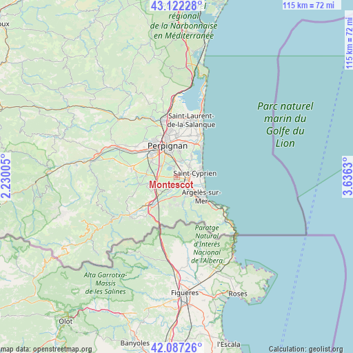
Montescot GPS coordinates[2]
42° 36' 24.912" North, 2° 55' 59.448" East
| Map corner | latitude | longitude |
|---|---|---|
| Upper-left | 43.12228°, | 2.23005° |
| Center: | 42.60692°, | 2.93318° |
| Lower-right: | 42.08726°, | 3.6363° |
| Map W x H: | 115.1×115.1 km | = 71.5×71.5mi |
| max Lat: | 51.07786° ⇑99.3% North |
| Montescot: | 42.60692° |
| min Lat: | ⇓0.7% South 41.3874° |
| min Long | Montescot | max Long |
| -5.08615° | 2.93318° | 9.52242° |
| W 56.8%⇐ | ⇒43.2% E |
Elevation
Elevation of Montescot is 14 m = 46 ft, and this is 179.7 m = 590 ft below average elevation for this country.
| Max E: |
2333 m = 7654 ft | 96% |
| Avg. | 193.7 m = 635 ft | |
| Montescot | 14 m = 46 ft | |
Min E: |
-1 m = -3 ft | 4% |
See also: France elevation on elevation.city.
Geographical zone
Montescot is located in North temperate zone (between Tropic of Cancer and the Arctic Circle). Distance of this Northern Tropic circle is 2131.5 km =1324.5 mi to South.| Distance of | km | miles | from Montescot |
|---|---|---|---|
| North Pole | 5269.6 | 3274.4 | to North |
| Arctic Circle | 2663.7 | 1655.1 | to North |
| Tropic Cancer | 2131.5 | 1324.5 | to South |
| Equator | 4737.4 | 2943.7 | to South |


Nearby cities:
15 places around Montescot: (largest is in red/bold)
• Alénya
5.3 km =3.3 mi,  48°
48°
• Bages
3.2 km =2 mi,  267°
267°
• Banyuls-dels-Aspres
7.1 km =4.4 mi,  229°
229°
• Brouilla
5.1 km =3.2 mi,  208°
208°
• Corneilla-del-Vercol
2.4 km =1.5 mi,  39°
39°
• Elne
3.2 km =2 mi,  103°
103°
• Latour-Bas-Elne
5.6 km =3.5 mi,  90°
90°
• Ortaffa
3.1 km =1.9 mi,  190°
190°
• Palau-del-Vidre
4.5 km =2.8 mi,  150°
150°
• Pollestres
6.4 km =4 mi,  307°
307°
• Saint-Jean-Lasseille
6.1 km =3.8 mi,  242°
242°
• Saleilles
5.5 km =3.4 mi,  17°
17°
• Sant Andreu de Sureda
6.9 km =4.3 mi, 152°
• Théza
3.8 km =2.4 mi, 22°
• Villeneuve-de-la-Raho
3.5 km =2.2 mi,  337°
337°
Sources, notices
• [Note1] Compared only with cities in France existing in our database
• [Src1] Map data: © OpenStreetMap contributors (CC-BY-SA)
• [Src2] Other city data from geonames.org with taken over terms of usage.
• [Src3] Geographical zone / Annual Mean Temperature by Robert A. Rohde @ Wikipedia
