Mont-de-Lans geodata
Mont-de-Lans (Auvergne-Rhône-Alpes) is a populated place; located in France in Europe/Paris (GMT+2) time zone. With population of 1,182 people, there are 7635 cities with bigger population in this country. Compared to other cities in France, 79.2% of cities are located further ↑North; 88.6% of cities are located further ←West and 99.7% of cities have lower elevation than Mont-de-Lans. Note1
Administrative division(s):
- Level 1: Auvergne-Rhône-Alpes
- Level 2: Département de l'Isère
- Level 3: Arrondissement de Grenoble
- Level 4: Les Deux Alpes


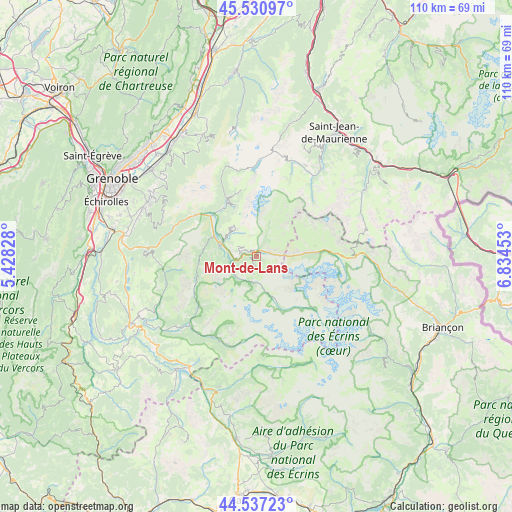
Mont-de-Lans GPS coordinates[2]
45° 2' 10.536" North, 6° 7' 53.076" East
| Map corner | latitude | longitude |
|---|---|---|
| Upper-left | 45.53097°, | 5.42828° |
| Center: | 45.03626°, | 6.13141° |
| Lower-right: | 44.53723°, | 6.83453° |
| Map W x H: | 110.5×110.5 km | = 68.7×68.7mi |
| max Lat: | 51.07786° ⇑79.2% North |
| Mont-de-Lans: | 45.03626° |
| min Lat: | ⇓20.8% South 41.3874° |
| min Long | Mont-de-Lans | max Long |
| -5.08615° | 6.13141° | 9.52242° |
| W 88.6%⇐ | ⇒11.4% E |
Elevation
Elevation of Mont-de-Lans is 1269 m = 4163 ft, and this is 1075.3 m = 3528 ft above average elevation for this country.
| Max E: |
2333 m = 7654 ft | 0.3% |
| Mont-de-Lans | 1269 m 4163 ft | |
| Avg. | 193.7 m = 635 ft | |
Min E: |
-1 m = -3 ft | 99.7% |
See also: France elevation on elevation.city.
Geographical zone
Mont-de-Lans is located in North temperate zone (between Tropic of Cancer and the Arctic Circle). Distance of this North polar circle is 2393.6 km =1487.3 mi to North.| Distance of | km | miles | from Mont-de-Lans |
|---|---|---|---|
| North Pole | 4999.5 | 3106.5 | to North |
| Arctic Circle | 2393.6 | 1487.3 | to North |
| Tropic Cancer | 2401.6 | 1492.3 | to South |
| Equator | 5007.6 | 3111.6 | to South |


Nearby cities:
15 places around Mont-de-Lans: (largest is in red/bold)
• Allemond
12.7 km =7.9 mi,  324°
324°
• Chamrousse
22.6 km =14 mi,  296°
296°
• Fontcouverte-la Toussuire
27.2 km =16.9 mi,  29°
29°
• Huez
7.7 km =4.8 mi,  311°
311°
• Le Bourg-d’Oisans
8 km =5 mi,  285°
285°
• Les Deux Alpes
2.8 km =1.7 mi,  189°
189°
• Livet-et-Gavet
17.5 km =10.9 mi, 297°
• Revel
26.3 km =16.3 mi, 309°
• Saint-Barthélemy-de-Séchilienne
23.8 km =14.8 mi,  273°
273°
• Saint-Honoré
26.9 km =16.7 mi,  247°
247°
• Saint-Pierre-de-Mésage
26.8 km =16.7 mi, 272°
• Séchilienne
23.6 km =14.7 mi,  275°
275°
• Vaulnaveys-le-Bas
25.1 km =15.6 mi, 286°
• Vaulnaveys-le-Haut
26.6 km =16.5 mi, 291°
• Vénosc
5.3 km =3.3 mi, 193°
Sources, notices
• [Note1] Compared only with cities in France existing in our database
• [Src1] Map data: © OpenStreetMap contributors (CC-BY-SA)
• [Src2] Other city data from geonames.org with taken over terms of usage.
• [Src3] Geographical zone / Annual Mean Temperature by Robert A. Rohde @ Wikipedia
