Saint-Honoré geodata
Saint-Honoré (Auvergne-Rhône-Alpes) is a populated place; located in France in Europe/Paris (GMT+2) time zone. With population of 848 people, there are 10102 cities with bigger population in this country. Compared to other cities in France, 80.1% of cities are located further ↑North; 85.2% of cities are located further ←West and 99.2% of cities have lower elevation than Saint-Honoré. Note1
Administrative division(s):
- Level 1: Auvergne-Rhône-Alpes
- Level 2: Département de l'Isère
- Level 3: Arrondissement de Grenoble
- Level 4: Saint-Honoré


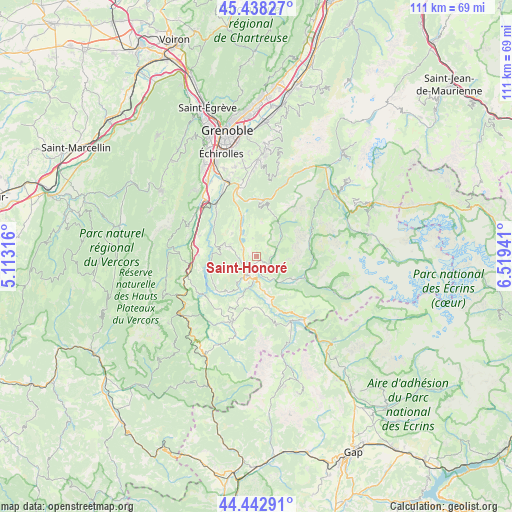
Saint-Honoré GPS coordinates[2]
44° 56' 33.9" North, 5° 48' 58.608" East
| Map corner | latitude | longitude |
|---|---|---|
| Upper-left | 45.43827°, | 5.11316° |
| Center: | 44.94275°, | 5.81628° |
| Lower-right: | 44.44291°, | 6.51941° |
| Map W x H: | 110.7×110.7 km | = 68.8×68.8mi |
| max Lat: | 51.07786° ⇑80.1% North |
| Saint-Honoré: | 44.94275° |
| min Lat: | ⇓19.9% South 41.3874° |
| min Long | Saint-Honoré | max Long |
| -5.08615° | 5.81628° | 9.52242° |
| W 85.2%⇐ | ⇒14.8% E |
Elevation
Elevation of Saint-Honoré is 1020 m = 3346 ft, and this is 826.3 m = 2711 ft above average elevation for this country.
| Max E: |
2333 m = 7654 ft | 0.8% |
| Saint-Honoré | 1020 m 3346 ft | |
| Avg. | 193.7 m = 635 ft | |
Min E: |
-1 m = -3 ft | 99.2% |
See also: France elevation on elevation.city.
Geographical zone
Saint-Honoré is located in North temperate zone (between Tropic of Cancer and the Arctic Circle). Distance of this Northern Tropic circle is 2391.2 km =1485.8 mi to South.| Distance of | km | miles | from Saint-Honoré |
|---|---|---|---|
| North Pole | 5009.9 | 3113 | to North |
| Arctic Circle | 2404 | 1493.8 | to North |
| Tropic Cancer | 2391.2 | 1485.8 | to South |
| Equator | 4997.2 | 3105.1 | to South |


Nearby cities:
15 places around Saint-Honoré: (largest is in red/bold)
• Champ-sur-Drac
15.6 km =9.7 mi,  334°
334°
• La Motte-Saint-Martin
7.8 km =4.8 mi,  277°
277°
• La Motte-d’Aveillans
6 km =3.7 mi,  288°
288°
• La Mure
5.1 km =3.2 mi,  205°
205°
• Mens
15 km =9.3 mi,  199°
199°
• Monestier-de-Clermont
14.5 km =9 mi,  259°
259°
• Notre-Dame-de-Mésage
14.1 km =8.8 mi,  341°
341°
• Pierre-Châtel
3.7 km =2.3 mi,  296°
296°
• Saint-Barthélemy
16 km =9.9 mi, 293°
• Saint-Barthélemy-de-Séchilienne
11.9 km =7.4 mi,  4°
4°
• Saint-Georges-de-Commiers
14.3 km =8.9 mi,  322°
322°
• Saint-Pierre-de-Mésage
11.7 km =7.3 mi,  350°
350°
• Sinard
12.5 km =7.8 mi,  271°
271°
• Séchilienne
12.9 km =8 mi,  5°
5°
• Vizille
15.5 km =9.6 mi, 346°
Sources, notices
• [Note1] Compared only with cities in France existing in our database
• [Src1] Map data: © OpenStreetMap contributors (CC-BY-SA)
• [Src2] Other city data from geonames.org with taken over terms of usage.
• [Src3] Geographical zone / Annual Mean Temperature by Robert A. Rohde @ Wikipedia
