Montaner geodata
Montaner (Nouvelle-Aquitaine) is a populated place; located in France in Europe/Paris (GMT+2) time zone. With population of 504 people, there are 15167 cities with bigger population in this country. Compared to other cities in France, 95% of cities are located further ↑North; 78.2% of cities are located further →East and 78.6% of cities have lower elevation than Montaner. Note1
Administrative division(s):
- Level 1: Nouvelle-Aquitaine
- Level 2: Département des Pyrénées-Atlantiques
- Level 3: Arrondissement de Pau
- Level 4: Montaner


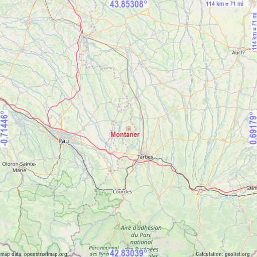
Montaner GPS coordinates[2]
43° 20' 38.004" North, 0° 0' 40.824" West
| Map corner | latitude | longitude |
|---|---|---|
| Upper-left | 43.85308°, | -0.71446° |
| Center: | 43.34389°, | -0.01134° |
| Lower-right: | 42.83039°, | 0.69179° |
| Map W x H: | 113.7×113.7 km | = 70.6×70.6mi |
| max Lat: | 51.07786° ⇑95% North |
| Montaner: | 43.34389° |
| min Lat: | ⇓5% South 41.3874° |
| min Long | Montaner | max Long |
| -5.08615° | -0.01134° | 9.52242° |
| W 21.8%⇐ | ⇒78.2% E |
Elevation
Elevation of Montaner is 278 m = 912 ft, and this is 84.3 m = 277 ft above average elevation for this country.
| Max E: |
2333 m = 7654 ft | 21.4% |
| Montaner | 278 m 912 ft | |
| Avg. | 193.7 m = 635 ft | |
Min E: |
-1 m = -3 ft | 78.6% |
See also: France elevation on elevation.city.
Geographical zone
Montaner is located in North temperate zone (between Tropic of Cancer and the Arctic Circle). Distance of this Northern Tropic circle is 2213.5 km =1375.4 mi to South.| Distance of | km | miles | from Montaner |
|---|---|---|---|
| North Pole | 5187.7 | 3223.5 | to North |
| Arctic Circle | 2581.8 | 1604.3 | to North |
| Tropic Cancer | 2213.5 | 1375.4 | to South |
| Equator | 4819.4 | 2994.6 | to South |


Nearby cities:
15 places around Montaner: (largest is in red/bold)
• Andrest
6.7 km =4.2 mi,  113°
113°
• Aureilhan
14.1 km =8.8 mi,  142°
142°
• Aurensan
9 km =5.6 mi,  118°
118°
• Azereix
14.2 km =8.8 mi,  181°
181°
• Bazet
8.6 km =5.3 mi,  132°
132°
• Bours
11.1 km =6.9 mi, 132°
• Ger
10.9 km =6.8 mi,  196°
196°
• Ibos
12.3 km =7.6 mi, 175°
• Lembeye
13.8 km =8.6 mi,  328°
328°
• Maubourguet
14.3 km =8.9 mi,  15°
15°
• Orleix
12.8 km =8 mi, 123°
• Oursbelille
7.5 km =4.7 mi,  150°
150°
• Pujo
6.4 km =4 mi,  86°
86°
• Rabastens-de-Bigorre
14 km =8.7 mi,  69°
69°
• Vic-en-Bigorre
7.2 km =4.5 mi,  48°
48°
Sources, notices
• [Note1] Compared only with cities in France existing in our database
• [Src1] Map data: © OpenStreetMap contributors (CC-BY-SA)
• [Src2] Other city data from geonames.org with taken over terms of usage.
• [Src3] Geographical zone / Annual Mean Temperature by Robert A. Rohde @ Wikipedia
