Aurensan geodata
Aurensan (Occitanie) is a populated place; located in France in Europe/Paris (GMT+2) time zone. With population of 688 people, there are 11973 cities with bigger population in this country. Compared to other cities in France, 95.5% of cities are located further ↑North; 77.3% of cities are located further →East and 76.8% of cities have lower elevation than Aurensan. Note1
Administrative division(s):
- Level 1: Occitanie
- Level 2: Département des Hautes-Pyrénées
- Level 3: Arrondissement de Tarbes
- Level 4: Aurensan


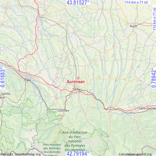
Aurensan GPS coordinates[2]
43° 18' 20.736" North, 0° 5' 10.68" East
| Map corner | latitude | longitude |
|---|---|---|
| Upper-left | 43.81527°, | -0.61683° |
| Center: | 43.30576°, | 0.0863° |
| Lower-right: | 42.79194°, | 0.78942° |
| Map W x H: | 113.8×113.8 km | = 70.7×70.7mi |
| max Lat: | 51.07786° ⇑95.5% North |
| Aurensan: | 43.30576° |
| min Lat: | ⇓4.5% South 41.3874° |
| min Long | Aurensan | max Long |
| -5.08615° | 0.0863° | 9.52242° |
| W 22.7%⇐ | ⇒77.3% E |
Elevation
Elevation of Aurensan is 262 m = 860 ft, and this is 68.3 m = 224 ft above average elevation for this country.
| Max E: |
2333 m = 7654 ft | 23.2% |
| Aurensan | 262 m 860 ft | |
| Avg. | 193.7 m = 635 ft | |
Min E: |
-1 m = -3 ft | 76.8% |
See also: France elevation on elevation.city.
Geographical zone
Aurensan is located in North temperate zone (between Tropic of Cancer and the Arctic Circle). Distance of this Northern Tropic circle is 2209.2 km =1372.7 mi to South.| Distance of | km | miles | from Aurensan |
|---|---|---|---|
| North Pole | 5191.9 | 3226.1 | to North |
| Arctic Circle | 2586 | 1606.9 | to North |
| Tropic Cancer | 2209.2 | 1372.7 | to South |
| Equator | 4815.1 | 2992 | to South |


Nearby cities:
15 places around Aurensan: (largest is in red/bold)
• Andrest
2.4 km =1.5 mi,  311°
311°
• Aureilhan
7 km =4.3 mi,  173°
173°
• Bazet
2.2 km =1.4 mi,  224°
224°
• Bours
3.2 km =2 mi, 174°
• Ibos
10.7 km =6.6 mi, 220°
• Montaner
9 km =5.6 mi,  298°
298°
• Orleix
4 km =2.5 mi,  136°
136°
• Oursbelille
4.8 km =3 mi,  241°
241°
• Pouyastruc
7.8 km =4.8 mi,  123°
123°
• Pujo
4.9 km =3 mi,  341°
341°
• Rabastens-de-Bigorre
10.5 km =6.5 mi,  29°
29°
• Sarrouilles
9.1 km =5.7 mi,  158°
158°
• Séméac
8.7 km =5.4 mi, 169°
• Tarbes
8.1 km =5 mi,  181°
181°
• Vic-en-Bigorre
9.4 km =5.8 mi, 344°
Sources, notices
• [Note1] Compared only with cities in France existing in our database
• [Src1] Map data: © OpenStreetMap contributors (CC-BY-SA)
• [Src2] Other city data from geonames.org with taken over terms of usage.
• [Src3] Geographical zone / Annual Mean Temperature by Robert A. Rohde @ Wikipedia
