Andrest geodata
Andrest (Occitanie) is a populated place; located in France in Europe/Paris (GMT+2) time zone. With population of 1,284 people, there are 7106 cities with bigger population in this country. Compared to other cities in France, 95.3% of cities are located further ↑North; 77.6% of cities are located further →East and 75.8% of cities have lower elevation than Andrest. Note1
Administrative division(s):
- Level 1: Occitanie
- Level 2: Département des Hautes-Pyrénées
- Level 3: Arrondissement de Tarbes
- Level 4: Andrest


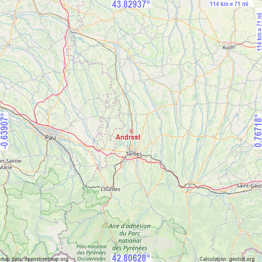
Andrest GPS coordinates[2]
43° 19' 11.928" North, 0° 3' 50.58" East
| Map corner | latitude | longitude |
|---|---|---|
| Upper-left | 43.82937°, | -0.63907° |
| Center: | 43.31998°, | 0.06405° |
| Lower-right: | 42.80628°, | 0.76718° |
| Map W x H: | 113.8×113.8 km | = 70.7×70.7mi |
| max Lat: | 51.07786° ⇑95.3% North |
| Andrest: | 43.31998° |
| min Lat: | ⇓4.7% South 41.3874° |
| min Long | Andrest | max Long |
| -5.08615° | 0.06405° | 9.52242° |
| W 22.4%⇐ | ⇒77.6% E |
Elevation
Elevation of Andrest is 255 m = 837 ft, and this is 61.3 m = 201 ft above average elevation for this country.
| Max E: |
2333 m = 7654 ft | 24.2% |
| Andrest | 255 m 837 ft | |
| Avg. | 193.7 m = 635 ft | |
Min E: |
-1 m = -3 ft | 75.8% |
See also: France elevation on elevation.city.
Geographical zone
Andrest is located in North temperate zone (between Tropic of Cancer and the Arctic Circle). Distance of this Northern Tropic circle is 2210.8 km =1373.7 mi to South.| Distance of | km | miles | from Andrest |
|---|---|---|---|
| North Pole | 5190.3 | 3225.1 | to North |
| Arctic Circle | 2584.4 | 1605.9 | to North |
| Tropic Cancer | 2210.8 | 1373.7 | to South |
| Equator | 4816.7 | 2993 | to South |


Nearby cities:
15 places around Andrest: (largest is in red/bold)
• Aureilhan
8.9 km =5.5 mi,  163°
163°
• Aurensan
2.4 km =1.5 mi,  131°
131°
• Bazet
3.2 km =2 mi,  175°
175°
• Bours
5.2 km =3.2 mi, 156°
• Ibos
10.9 km =6.8 mi,  208°
208°
• Montaner
6.7 km =4.2 mi,  293°
293°
• Orleix
6.4 km =4 mi, 134°
• Oursbelille
4.5 km =2.8 mi, 211°
• Pouyastruc
10.2 km =6.3 mi, 125°
• Pujo
3.1 km =1.9 mi,  4°
4°
• Rabastens-de-Bigorre
10.3 km =6.4 mi,  43°
43°
• Sarrouilles
11.3 km =7 mi,  153°
153°
• Séméac
10.7 km =6.6 mi, 161°
• Tarbes
9.8 km =6.1 mi,  170°
170°
• Vic-en-Bigorre
7.5 km =4.7 mi,  354°
354°
Sources, notices
• [Note1] Compared only with cities in France existing in our database
• [Src1] Map data: © OpenStreetMap contributors (CC-BY-SA)
• [Src2] Other city data from geonames.org with taken over terms of usage.
• [Src3] Geographical zone / Annual Mean Temperature by Robert A. Rohde @ Wikipedia
