Maubourguet geodata
Maubourguet (Occitanie) is a populated place; located in France in Europe/Paris (GMT+2) time zone. With population of 2,492 people, there are 3902 cities with bigger population in this country. Compared to other cities in France, 93.5% of cities are located further ↑North; 77.8% of cities are located further →East and 62.5% of cities have lower elevation than Maubourguet. Note1
Administrative division(s):
- Level 1: Occitanie
- Level 2: Département des Hautes-Pyrénées
- Level 3: Arrondissement de Tarbes
- Level 4: Maubourguet


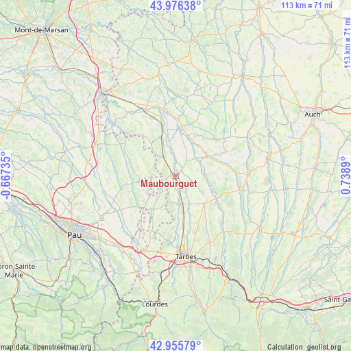
Maubourguet GPS coordinates[2]
43° 28' 5.664" North, 0° 2' 8.808" East
| Map corner | latitude | longitude |
|---|---|---|
| Upper-left | 43.97638°, | -0.66735° |
| Center: | 43.46824°, | 0.03578° |
| Lower-right: | 42.95579°, | 0.7389° |
| Map W x H: | 113.5×113.5 km | = 70.5×70.5mi |
| max Lat: | 51.07786° ⇑93.5% North |
| Maubourguet: | 43.46824° |
| min Lat: | ⇓6.5% South 41.3874° |
| min Long | Maubourguet | max Long |
| -5.08615° | 0.03578° | 9.52242° |
| W 22.2%⇐ | ⇒77.8% E |
Elevation
Elevation of Maubourguet is 182 m = 597 ft, and this is 11.7 m = 38 ft below average elevation for this country.
| Max E: |
2333 m = 7654 ft | 37.5% |
| Avg. | 193.7 m = 635 ft | |
| Maubourguet | 182 m = 597 ft | |
Min E: |
-1 m = -3 ft | 62.5% |
See also: France elevation on elevation.city.
Geographical zone
Maubourguet is located in North temperate zone (between Tropic of Cancer and the Arctic Circle). Distance of this Northern Tropic circle is 2227.3 km =1384 mi to South.| Distance of | km | miles | from Maubourguet |
|---|---|---|---|
| North Pole | 5173.8 | 3214.8 | to North |
| Arctic Circle | 2568 | 1595.7 | to North |
| Tropic Cancer | 2227.3 | 1384 | to South |
| Equator | 4833.2 | 3003.2 | to South |


Nearby cities:
15 places around Maubourguet: (largest is in red/bold)
• Andrest
16.6 km =10.3 mi,  172°
172°
• Aurensan
18.5 km =11.5 mi, 167°
• Bazet
19.8 km =12.3 mi, 172°
• Beaumarchés
13.4 km =8.3 mi,  16°
16°
• Castelnau-Rivière-Basse
13.6 km =8.5 mi,  337°
337°
• Lembeye
11.1 km =6.9 mi,  259°
259°
• Madiran
11.4 km =7.1 mi,  322°
322°
• Marciac
11.8 km =7.3 mi,  58°
58°
• Montaner
14.3 km =8.9 mi,  195°
195°
• Plaisance
15.2 km =9.4 mi,  3°
3°
• Pujo
13.7 km =8.5 mi, 169°
• Rabastens-de-Bigorre
12.9 km =8 mi,  133°
133°
• Vic-en-Bigorre
9.2 km =5.7 mi, 170°
• Viella
20.2 km =12.6 mi, 315°
• Villecomtal-sur-Arros
15.3 km =9.5 mi,  119°
119°
Sources, notices
• [Note1] Compared only with cities in France existing in our database
• [Src1] Map data: © OpenStreetMap contributors (CC-BY-SA)
• [Src2] Other city data from geonames.org with taken over terms of usage.
• [Src3] Geographical zone / Annual Mean Temperature by Robert A. Rohde @ Wikipedia
