Monchecourt geodata
Monchecourt (Hauts-de-France) is a populated place; located in France in Europe/Paris (GMT+2) time zone. With population of 2,738 people, there are 3580 cities with bigger population in this country. Compared to other cities in France, 95.6% of cities are located further ↓South; 60.7% of cities are located further ←West and 80.6% of cities have higher elevation than Monchecourt. Note1
Administrative division(s):
- Level 1: Hauts-de-France
- Level 2: Nord
- Level 3: Arrondissement de Douai
- Level 4: Monchecourt


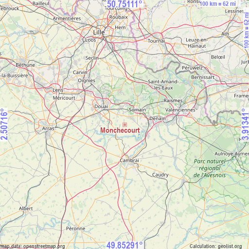
Monchecourt GPS coordinates[2]
50° 18' 14.868" North, 3° 12' 37.044" East
| Map corner | latitude | longitude |
|---|---|---|
| Upper-left | 50.75111°, | 2.50716° |
| Center: | 50.30413°, | 3.21029° |
| Lower-right: | 49.85291°, | 3.91341° |
| Map W x H: | 99.9×99.9 km | = 62.1×62.1mi |
| max Lat: | 51.07786° ⇑4.4% North |
| Monchecourt: | 50.30413° |
| min Lat: | ⇓95.6% South 41.3874° |
| min Long | Monchecourt | max Long |
| -5.08615° | 3.21029° | 9.52242° |
| W 60.7%⇐ | ⇒39.3% E |
Elevation
Elevation of Monchecourt is 53 m = 174 ft, and this is 140.7 m = 462 ft below average elevation for this country.
| Max E: |
2333 m = 7654 ft | 80.6% |
| Avg. | 193.7 m = 635 ft | |
| Monchecourt | 53 m = 174 ft | |
Min E: |
-1 m = -3 ft | 19.4% |
See also: France elevation on elevation.city.
Geographical zone
Monchecourt is located in North temperate zone (between Tropic of Cancer and the Arctic Circle). Distance of this North polar circle is 1807.9 km =1123.4 mi to North.| Distance of | km | miles | from Monchecourt |
|---|---|---|---|
| North Pole | 4413.8 | 2742.6 | to North |
| Arctic Circle | 1807.9 | 1123.4 | to North |
| Tropic Cancer | 2987.4 | 1856.3 | to South |
| Equator | 5593.3 | 3475.5 | to South |


Nearby cities:
15 places around Monchecourt: (largest is in red/bold)
• Aniche
4.2 km =2.6 mi,  46°
46°
• Auberchicourt
3.6 km =2.2 mi,  26°
26°
• Bugnicourt
4.2 km =2.6 mi,  250°
250°
• Erchin
3.4 km =2.1 mi,  295°
295°
• Fressain
2.2 km =1.4 mi,  211°
211°
• Féchain
4.2 km =2.6 mi,  180°
180°
• Hem-Lenglet
5.3 km =3.3 mi,  165°
165°
• Lewarde
5.2 km =3.2 mi,  324°
324°
• Marcq-en-Ostrevent
2.9 km =1.8 mi,  136°
136°
• Marquette-en-Ostrevant
4.6 km =2.9 mi,  120°
120°
• Masny
4.9 km =3 mi,  352°
352°
• Villers-au-Tertre
2 km =1.2 mi,  261°
261°
• Wasnes-au-Bac
5.1 km =3.2 mi, 136°
• Écaillon
5.2 km =3.2 mi,  5°
5°
• Émerchicourt
2.5 km =1.6 mi,  80°
80°
Sources, notices
• [Note1] Compared only with cities in France existing in our database
• [Src1] Map data: © OpenStreetMap contributors (CC-BY-SA)
• [Src2] Other city data from geonames.org with taken over terms of usage.
• [Src3] Geographical zone / Annual Mean Temperature by Robert A. Rohde @ Wikipedia
