Villers-au-Tertre geodata
Villers-au-Tertre (Hauts-de-France) is a populated place; located in France in Europe/Paris (GMT+2) time zone. With population of 670 people, there are 12215 cities with bigger population in this country. Compared to other cities in France, 95.6% of cities are located further ↓South; 60.3% of cities are located further ←West and 72.3% of cities have higher elevation than Villers-au-Tertre. Note1
Administrative division(s):
- Level 1: Hauts-de-France
- Level 2: Nord
- Level 3: Arrondissement de Douai
- Level 4: Villers-au-Tertre


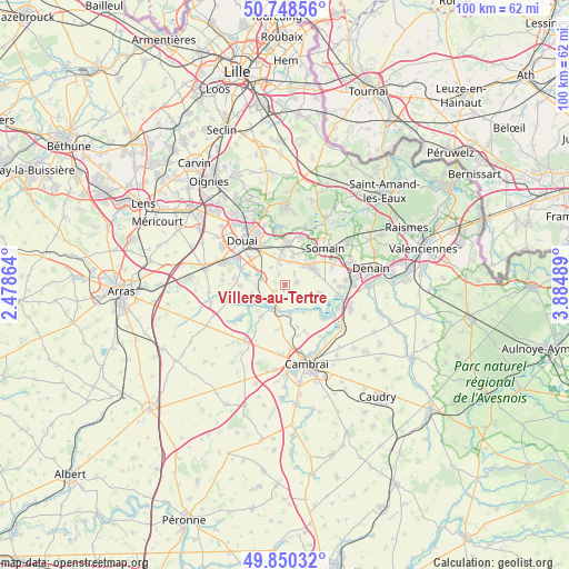
Villers-au-Tertre GPS coordinates[2]
50° 18' 5.616" North, 3° 10' 54.336" East
| Map corner | latitude | longitude |
|---|---|---|
| Upper-left | 50.74856°, | 2.47864° |
| Center: | 50.30156°, | 3.18176° |
| Lower-right: | 49.85032°, | 3.88489° |
| Map W x H: | 99.9×99.9 km | = 62.1×62.1mi |
| max Lat: | 51.07786° ⇑4.4% North |
| Villers-au-Tertre: | 50.30156° |
| min Lat: | ⇓95.6% South 41.3874° |
| min Long | Villers-au-Tert | max Long |
| -5.08615° | 3.18176° | 9.52242° |
| W 60.3%⇐ | ⇒39.7% E |
Elevation
Elevation of Villers-au-Tertre is 73 m = 240 ft, and this is 120.7 m = 396 ft below average elevation for this country.
| Max E: |
2333 m = 7654 ft | 72.3% |
| Avg. | 193.7 m = 635 ft | |
| Villers-au-Tertre | 73 m = 240 ft | |
Min E: |
-1 m = -3 ft | 27.7% |
See also: France elevation on elevation.city.
Geographical zone
Villers-au-Tertre is located in North temperate zone (between Tropic of Cancer and the Arctic Circle). Distance of this North polar circle is 1808.2 km =1123.6 mi to North.| Distance of | km | miles | from Villers-au-Tertre |
|---|---|---|---|
| North Pole | 4414.1 | 2742.8 | to North |
| Arctic Circle | 1808.2 | 1123.6 | to North |
| Tropic Cancer | 2987.1 | 1856.1 | to South |
| Equator | 5593 | 3475.3 | to South |


Nearby cities:
15 places around Villers-au-Tertre: (largest is in red/bold)
• Aubencheul-au-Bac
5.3 km =3.3 mi,  198°
198°
• Auberchicourt
5.1 km =3.2 mi,  46°
46°
• Aubigny-au-Bac
4.4 km =2.7 mi, 196°
• Bugnicourt
2.2 km =1.4 mi,  239°
239°
• Cantin
3.9 km =2.4 mi,  281°
281°
• Erchin
2.1 km =1.3 mi,  328°
328°
• Fressain
1.8 km =1.1 mi,  150°
150°
• Fressies
5.2 km =3.2 mi,  169°
169°
• Féchain
4.4 km =2.7 mi, 152°
• Guesnain
5.8 km =3.6 mi,  337°
337°
• Lewarde
4.6 km =2.9 mi,  347°
347°
• Marcq-en-Ostrevent
4.4 km =2.7 mi,  113°
113°
• Masny
5.3 km =3.3 mi,  15°
15°
• Monchecourt
2 km =1.2 mi,  81°
81°
• Émerchicourt
4.6 km =2.9 mi, 81°
Sources, notices
• [Note1] Compared only with cities in France existing in our database
• [Src1] Map data: © OpenStreetMap contributors (CC-BY-SA)
• [Src2] Other city data from geonames.org with taken over terms of usage.
• [Src3] Geographical zone / Annual Mean Temperature by Robert A. Rohde @ Wikipedia
