Émerchicourt geodata
Émerchicourt (Hauts-de-France) is a populated place; located in France in Europe/Paris (GMT+2) time zone. With population of 1,015 people, there are 8732 cities with bigger population in this country. Compared to other cities in France, 95.6% of cities are located further ↓South; 61.3% of cities are located further ←West and 75.8% of cities have higher elevation than Émerchicourt. Note1
Administrative division(s):
- Level 1: Hauts-de-France
- Level 2: Nord
- Level 3: Arrondissement de Valenciennes
- Level 4: Émerchicourt


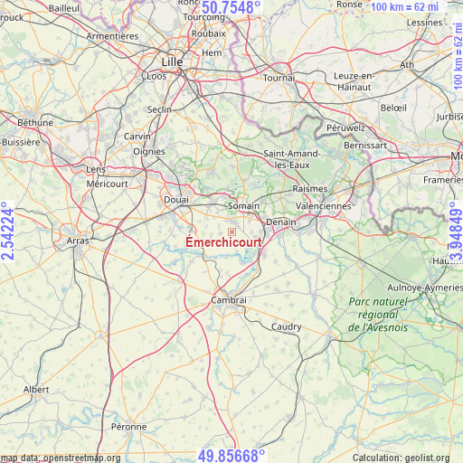
Émerchicourt GPS coordinates[2]
50° 18' 28.296" North, 3° 14' 43.332" East
| Map corner | latitude | longitude |
|---|---|---|
| Upper-left | 50.7548°, | 2.54224° |
| Center: | 50.30786°, | 3.24537° |
| Lower-right: | 49.85668°, | 3.94849° |
| Map W x H: | 99.9×99.9 km | = 62.1×62.1mi |
| max Lat: | 51.07786° ⇑4.4% North |
| Émerchicourt: | 50.30786° |
| min Lat: | ⇓95.6% South 41.3874° |
| min Long | Émerchicourt | max Long |
| -5.08615° | 3.24537° | 9.52242° |
| W 61.3%⇐ | ⇒38.7% E |
Elevation
Elevation of Émerchicourt is 65 m = 213 ft, and this is 128.7 m = 422 ft below average elevation for this country.
| Max E: |
2333 m = 7654 ft | 75.8% |
| Avg. | 193.7 m = 635 ft | |
| Émerchicourt | 65 m = 213 ft | |
Min E: |
-1 m = -3 ft | 24.2% |
See also: France elevation on elevation.city.
Geographical zone
Émerchicourt is located in North temperate zone (between Tropic of Cancer and the Arctic Circle). Distance of this North polar circle is 1807.5 km =1123.1 mi to North.| Distance of | km | miles | from Émerchicourt |
|---|---|---|---|
| North Pole | 4413.4 | 2742.4 | to North |
| Arctic Circle | 1807.5 | 1123.1 | to North |
| Tropic Cancer | 2987.8 | 1856.5 | to South |
| Equator | 5593.7 | 3475.8 | to South |


Nearby cities:
15 places around Émerchicourt: (largest is in red/bold)
• Abscon
4.8 km =3 mi,  53°
53°
• Aniche
2.5 km =1.6 mi,  13°
13°
• Auberchicourt
3 km =1.9 mi,  343°
343°
• Bouchain
5.5 km =3.4 mi,  117°
117°
• Fressain
4.3 km =2.7 mi,  237°
237°
• Féchain
5.2 km =3.2 mi,  208°
208°
• Hem-Lenglet
5.7 km =3.5 mi,  192°
192°
• Marcq-en-Ostrevent
2.5 km =1.6 mi, 191°
• Marquette-en-Ostrevant
3.1 km =1.9 mi,  150°
150°
• Masny
5.4 km =3.4 mi,  325°
325°
• Mastaing
4.2 km =2.6 mi,  92°
92°
• Monchecourt
2.5 km =1.6 mi,  260°
260°
• Villers-au-Tertre
4.6 km =2.9 mi, 261°
• Wasnes-au-Bac
4.2 km =2.6 mi,  165°
165°
• Écaillon
5.1 km =3.2 mi, 336°
Sources, notices
• [Note1] Compared only with cities in France existing in our database
• [Src1] Map data: © OpenStreetMap contributors (CC-BY-SA)
• [Src2] Other city data from geonames.org with taken over terms of usage.
• [Src3] Geographical zone / Annual Mean Temperature by Robert A. Rohde @ Wikipedia
