Miramas geodata
Miramas (Provence-Alpes-Côte d'Azur) is a populated place; located in France in Europe/Paris (GMT+2) time zone. With population of 24,173 people, there are 367 cities with bigger population in this country. Compared to other cities in France, 92% of cities are located further ↑North; 77.7% of cities are located further ←West and 81.8% of cities have higher elevation than Miramas. Note1
Administrative division(s):
- Level 1: Provence-Alpes-Côte d'Azur
- Level 2: Département des Bouches-du-Rhône
- Level 3: Arrondissement d'Istres
- Level 4: Miramas


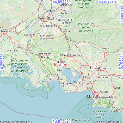
Miramas GPS coordinates[2]
43° 35' 6.288" North, 5° 0' 9.648" East
| Map corner | latitude | longitude |
|---|---|---|
| Upper-left | 44.09223°, | 4.29956° |
| Center: | 43.58508°, | 5.00268° |
| Lower-right: | 43.07362°, | 5.70581° |
| Map W x H: | 113.3×113.3 km | = 70.4×70.4mi |
| max Lat: | 51.07786° ⇑92% North |
| Miramas: | 43.58508° |
| min Lat: | ⇓8% South 41.3874° |
| min Long | Miramas | max Long |
| -5.08615° | 5.00268° | 9.52242° |
| W 77.7%⇐ | ⇒22.3% E |
Elevation
Elevation of Miramas is 50 m = 164 ft, and this is 143.7 m = 471 ft below average elevation for this country.
| Max E: |
2333 m = 7654 ft | 81.8% |
| Avg. | 193.7 m = 635 ft | |
| Miramas | 50 m = 164 ft | |
Min E: |
-1 m = -3 ft | 18.2% |
See also: France elevation on elevation.city.
Geographical zone
Miramas is located in North temperate zone (between Tropic of Cancer and the Arctic Circle). Distance of this Northern Tropic circle is 2240.3 km =1392.1 mi to South.| Distance of | km | miles | from Miramas |
|---|---|---|---|
| North Pole | 5160.9 | 3206.8 | to North |
| Arctic Circle | 2555 | 1587.6 | to North |
| Tropic Cancer | 2240.3 | 1392.1 | to South |
| Equator | 4846.2 | 3011.3 | to South |


Nearby cities:
15 places around Miramas: (largest is in red/bold)
• Aureille
14.4 km =8.9 mi,  341°
341°
• Aurons
15.3 km =9.5 mi,  54°
54°
• Cornillon-Confoux
6.1 km =3.8 mi,  114°
114°
• Eyguières
12.4 km =7.7 mi,  10°
10°
• Grans
5.5 km =3.4 mi,  61°
61°
• Istres
8.1 km =5 mi,  188°
188°
• La Barben
14.9 km =9.3 mi,  70°
70°
• La Fare-les-Oliviers
15.9 km =9.9 mi,  103°
103°
• Lamanon
14.5 km =9 mi,  28°
28°
• Lançon-Provence
10.1 km =6.3 mi,  85°
85°
• Mouriès
15.8 km =9.8 mi,  317°
317°
• Pélissanne
13.1 km =8.1 mi, 66°
• Saint-Chamas
4.6 km =2.9 mi,  145°
145°
• Saint-Mitre-les-Remparts
14.5 km =9 mi,  176°
176°
• Salon-de-Provence
9.8 km =6.1 mi, 49°
Sources, notices
• [Note1] Compared only with cities in France existing in our database
• [Src1] Map data: © OpenStreetMap contributors (CC-BY-SA)
• [Src2] Other city data from geonames.org with taken over terms of usage.
• [Src3] Geographical zone / Annual Mean Temperature by Robert A. Rohde @ Wikipedia
