Cornillon-Confoux geodata
Cornillon-Confoux (Provence-Alpes-Côte d'Azur) is a populated place; located in France in Europe/Paris (GMT+2) time zone. With population of 1,234 people, there are 7360 cities with bigger population in this country. Compared to other cities in France, 92.3% of cities are located further ↑North; 78.4% of cities are located further ←West and 77.8% of cities have higher elevation than Cornillon-Confoux. Note1
Administrative division(s):
- Level 1: Provence-Alpes-Côte d'Azur
- Level 2: Département des Bouches-du-Rhône
- Level 3: Arrondissement d'Istres
- Level 4: Cornillon-Confoux


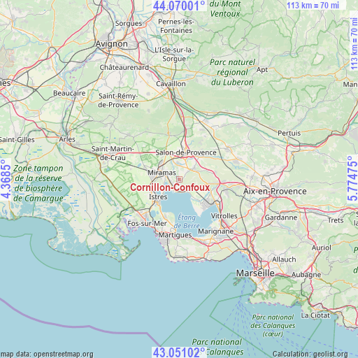
Cornillon-Confoux GPS coordinates[2]
43° 33' 45.612" North, 5° 4' 17.832" East
| Map corner | latitude | longitude |
|---|---|---|
| Upper-left | 44.07001°, | 4.3685° |
| Center: | 43.56267°, | 5.07162° |
| Lower-right: | 43.05102°, | 5.77475° |
| Map W x H: | 113.3×113.3 km | = 70.4×70.4mi |
| max Lat: | 51.07786° ⇑92.3% North |
| Cornillon-Confoux: | 43.56267° |
| min Lat: | ⇓7.7% South 41.3874° |
| min Long | Cornillon-Confo | max Long |
| -5.08615° | 5.07162° | 9.52242° |
| W 78.4%⇐ | ⇒21.6% E |
Elevation
Elevation of Cornillon-Confoux is 60 m = 197 ft, and this is 133.7 m = 439 ft below average elevation for this country.
| Max E: |
2333 m = 7654 ft | 77.8% |
| Avg. | 193.7 m = 635 ft | |
| Cornillon-Confoux | 60 m = 197 ft | |
Min E: |
-1 m = -3 ft | 22.2% |
See also: France elevation on elevation.city.
Geographical zone
Cornillon-Confoux is located in North temperate zone (between Tropic of Cancer and the Arctic Circle). Distance of this Northern Tropic circle is 2237.8 km =1390.5 mi to South.| Distance of | km | miles | from Cornillon-Confoux |
|---|---|---|---|
| North Pole | 5163.3 | 3208.3 | to North |
| Arctic Circle | 2557.5 | 1589.2 | to North |
| Tropic Cancer | 2237.8 | 1390.5 | to South |
| Equator | 4843.7 | 3009.7 | to South |


Nearby cities:
15 places around Cornillon-Confoux: (largest is in red/bold)
• Aurons
13.3 km =8.3 mi,  31°
31°
• Berre-l'Étang
12.3 km =7.6 mi,  139°
139°
• Coudoux
14.3 km =8.9 mi,  92°
92°
• Eyguières
15 km =9.3 mi,  347°
347°
• Grans
5.2 km =3.2 mi, 352°
• Istres
8.7 km =5.4 mi,  231°
231°
• La Barben
11.3 km =7 mi,  48°
48°
• La Fare-les-Oliviers
10 km =6.2 mi,  97°
97°
• Lamanon
15.3 km =9.5 mi,  5°
5°
• Lançon-Provence
5.6 km =3.5 mi, 53°
• Miramas
6.1 km =3.8 mi,  294°
294°
• Pélissanne
10.1 km =6.3 mi,  39°
39°
• Saint-Chamas
3.2 km =2 mi,  245°
245°
• Saint-Mitre-les-Remparts
12.8 km =8 mi,  201°
201°
• Salon-de-Provence
9 km =5.6 mi, 11°
Sources, notices
• [Note1] Compared only with cities in France existing in our database
• [Src1] Map data: © OpenStreetMap contributors (CC-BY-SA)
• [Src2] Other city data from geonames.org with taken over terms of usage.
• [Src3] Geographical zone / Annual Mean Temperature by Robert A. Rohde @ Wikipedia
