Istres geodata
Istres (Provence-Alpes-Côte d'Azur) is a seat of a third-order administrative division; located in France in Europe/Paris (GMT+2) time zone. With population of 44,373 people, there are 156 cities with bigger population in this country. Compared to other cities in France, 92.9% of cities are located further ↑North; 77.5% of cities are located further ←West and 96% of cities have higher elevation than Istres. Note1
Administrative division(s):
- Level 1: Provence-Alpes-Côte d'Azur
- Level 2: Département des Bouches-du-Rhône
- Level 3: Arrondissement d'Istres
- Level 4: Istres


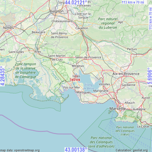
Istres GPS coordinates[2]
43° 30' 48.42" North, 4° 59' 14.892" East
| Map corner | latitude | longitude |
|---|---|---|
| Upper-left | 44.02121°, | 4.28435° |
| Center: | 43.51345°, | 4.98747° |
| Lower-right: | 43.00138°, | 5.6906° |
| Map W x H: | 113.4×113.4 km | = 70.5×70.5mi |
| max Lat: | 51.07786° ⇑92.9% North |
| Istres: | 43.51345° |
| min Lat: | ⇓7.1% South 41.3874° |
| min Long | Istres | max Long |
| -5.08615° | 4.98747° | 9.52242° |
| W 77.5%⇐ | ⇒22.5% E |
Elevation
Elevation of Istres is 14 m = 46 ft, and this is 179.7 m = 590 ft below average elevation for this country.
| Max E: |
2333 m = 7654 ft | 96% |
| Avg. | 193.7 m = 635 ft | |
| Istres | 14 m = 46 ft | |
Min E: |
-1 m = -3 ft | 4% |
See also: Istres elevation on elevation.city.
Geographical zone
Istres is located in North temperate zone (between Tropic of Cancer and the Arctic Circle). Distance of this Northern Tropic circle is 2232.3 km =1387.1 mi to South.| Distance of | km | miles | from Istres |
|---|---|---|---|
| North Pole | 5168.8 | 3211.7 | to North |
| Arctic Circle | 2562.9 | 1592.5 | to North |
| Tropic Cancer | 2232.3 | 1387.1 | to South |
| Equator | 4838.2 | 3006.3 | to South |


Nearby cities:
15 places around Istres: (largest is in red/bold)
• Berre-l'Étang
15.3 km =9.5 mi,  104°
104°
• Cornillon-Confoux
8.7 km =5.4 mi,  51°
51°
• Fos-sur-Mer
9.1 km =5.7 mi,  202°
202°
• Grans
12.2 km =7.6 mi,  29°
29°
• La Fare-les-Oliviers
17.2 km =10.7 mi,  75°
75°
• Lançon-Provence
14.3 km =8.9 mi, 52°
• Martigues
13 km =8.1 mi,  155°
155°
• Miramas
8.1 km =5 mi,  8°
8°
• Port-Saint-Louis-du-Rhône
19.1 km =11.9 mi,  222°
222°
• Port-de-Bouc
11.9 km =7.4 mi,  182°
182°
• Pélissanne
18.8 km =11.7 mi, 45°
• Saint-Chamas
5.6 km =3.5 mi,  42°
42°
• Saint-Martin-de-Crau
19.9 km =12.4 mi,  314°
314°
• Saint-Mitre-les-Remparts
6.8 km =4.2 mi, 161°
• Salon-de-Provence
16.7 km =10.4 mi, 31°
Sources, notices
• [Note1] Compared only with cities in France existing in our database
• [Src1] Map data: © OpenStreetMap contributors (CC-BY-SA)
• [Src2] Other city data from geonames.org with taken over terms of usage.
• [Src3] Geographical zone / Annual Mean Temperature by Robert A. Rohde @ Wikipedia
