Miniac-Morvan geodata
Miniac-Morvan (Brittany) is a populated place; located in France in Europe/Paris (GMT+2) time zone. With population of 3,045 people, there are 3199 cities with bigger population in this country. Compared to other cities in France, 68.6% of cities are located further ↓South; 94.5% of cities are located further →East and 88.3% of cities have higher elevation than Miniac-Morvan. Note1
Administrative division(s):
- Level 1: Brittany
- Level 2: Département d'Ille-et-Vilaine
- Level 3: Arrondissement de Saint-Malo
- Level 4: Miniac-Morvan


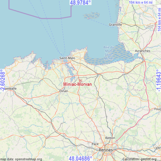
Miniac-Morvan GPS coordinates[2]
48° 30' 53.172" North, 1° 53' 58.38" West
| Map corner | latitude | longitude |
|---|---|---|
| Upper-left | 48.9784°, | -2.60268° |
| Center: | 48.51477°, | -1.89955° |
| Lower-right: | 48.04686°, | -1.19643° |
| Map W x H: | 103.6×103.6 km | = 64.4×64.4mi |
| max Lat: | 51.07786° ⇑31.4% North |
| Miniac-Morvan: | 48.51477° |
| min Lat: | ⇓68.6% South 41.3874° |
| min Long | Miniac-Morvan | max Long |
| -5.08615° | -1.89955° | 9.52242° |
| W 5.5%⇐ | ⇒94.5% E |
Elevation
Elevation of Miniac-Morvan is 34 m = 112 ft, and this is 159.7 m = 524 ft below average elevation for this country.
| Max E: |
2333 m = 7654 ft | 88.3% |
| Avg. | 193.7 m = 635 ft | |
| Miniac-Morvan | 34 m = 112 ft | |
Min E: |
-1 m = -3 ft | 11.7% |
See also: France elevation on elevation.city.
Geographical zone
Miniac-Morvan is located in North temperate zone (between Tropic of Cancer and the Arctic Circle). Distance of this North polar circle is 2006.8 km =1247 mi to North.| Distance of | km | miles | from Miniac-Morvan |
|---|---|---|---|
| North Pole | 4612.7 | 2866.2 | to North |
| Arctic Circle | 2006.8 | 1247 | to North |
| Tropic Cancer | 2788.4 | 1732.6 | to South |
| Equator | 5394.3 | 3351.9 | to South |


Nearby cities:
15 places around Miniac-Morvan: (largest is in red/bold)
• Châteauneuf-d’Ille-et-Vilaine
5.5 km =3.4 mi,  337°
337°
• La Vicomté-sur-Rance
6.6 km =4.1 mi,  246°
246°
• La Ville-ès-Nonais
5.3 km =3.3 mi,  313°
313°
• Langrolay-sur-Rance
8.4 km =5.2 mi,  297°
297°
• Lanhélin
8.2 km =5.1 mi,  140°
140°
• Le Tronchet
5.6 km =3.5 mi,  124°
124°
• Plerguer
4 km =2.5 mi,  70°
70°
• Pleudihen-sur-Rance
4.9 km =3 mi,  272°
272°
• Plouër-sur-Rance
7.7 km =4.8 mi,  279°
279°
• Roz-Landrieux
6.9 km =4.3 mi,  62°
62°
• Saint-Guinoux
6.9 km =4.3 mi,  9°
9°
• Saint-Hélen
6.6 km =4.1 mi,  221°
221°
• Saint-Pierre-de-Plesguen
7.7 km =4.8 mi,  187°
187°
• Saint-Père
8.3 km =5.2 mi,  347°
347°
• Saint-Suliac
8.2 km =5.1 mi,  319°
319°
Sources, notices
• [Note1] Compared only with cities in France existing in our database
• [Src1] Map data: © OpenStreetMap contributors (CC-BY-SA)
• [Src2] Other city data from geonames.org with taken over terms of usage.
• [Src3] Geographical zone / Annual Mean Temperature by Robert A. Rohde @ Wikipedia
