Pleudihen-sur-Rance geodata
Pleudihen-sur-Rance (Brittany) is a populated place; located in France in Europe/Paris (GMT+2) time zone. With population of 2,618 people, there are 3727 cities with bigger population in this country. Compared to other cities in France, 68.7% of cities are located further ↓South; 94.7% of cities are located further →East and 86.7% of cities have higher elevation than Pleudihen-sur-Rance. Note1
Administrative division(s):
- Level 1: Brittany
- Level 2: Département des Côtes-d’Armor
- Level 3: Arrondissement de Dinan
- Level 4: Pleudihen-sur-Rance


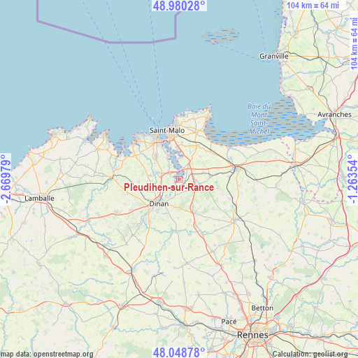
Pleudihen-sur-Rance GPS coordinates[2]
48° 31' 0.012" North, 1° 58' 0.012" West
| Map corner | latitude | longitude |
|---|---|---|
| Upper-left | 48.98028°, | -2.66979° |
| Center: | 48.51667°, | -1.96667° |
| Lower-right: | 48.04878°, | -1.26354° |
| Map W x H: | 103.6×103.6 km | = 64.4×64.4mi |
| max Lat: | 51.07786° ⇑31.3% North |
| Pleudihen-sur-Rance: | 48.51667° |
| min Lat: | ⇓68.7% South 41.3874° |
| min Long | Pleudihen-sur-R | max Long |
| -5.08615° | -1.96667° | 9.52242° |
| W 5.3%⇐ | ⇒94.7% E |
Elevation
Elevation of Pleudihen-sur-Rance is 38 m = 125 ft, and this is 155.7 m = 511 ft below average elevation for this country.
| Max E: |
2333 m = 7654 ft | 86.7% |
| Avg. | 193.7 m = 635 ft | |
| Pleudihen-sur-Rance | 38 m = 125 ft | |
Min E: |
-1 m = -3 ft | 13.3% |
See also: France elevation on elevation.city.
Geographical zone
Pleudihen-sur-Rance is located in North temperate zone (between Tropic of Cancer and the Arctic Circle). Distance of this North polar circle is 2006.6 km =1246.8 mi to North.| Distance of | km | miles | from Pleudihen-sur-Rance |
|---|---|---|---|
| North Pole | 4612.5 | 2866.1 | to North |
| Arctic Circle | 2006.6 | 1246.8 | to North |
| Tropic Cancer | 2788.6 | 1732.8 | to South |
| Equator | 5394.5 | 3352 | to South |


Nearby cities:
15 places around Pleudihen-sur-Rance: (largest is in red/bold)
• Châteauneuf-d’Ille-et-Vilaine
5.7 km =3.5 mi,  29°
29°
• La Vicomté-sur-Rance
3 km =1.9 mi,  201°
201°
• La Ville-ès-Nonais
3.6 km =2.2 mi,  17°
17°
• Langrolay-sur-Rance
4.4 km =2.7 mi,  326°
326°
• Lanvallay
8.2 km =5.1 mi,  213°
213°
• Le Minihic-sur-Rance
7.5 km =4.7 mi,  335°
335°
• Miniac-Morvan
4.9 km =3 mi,  92°
92°
• Pleslin-Trigavou
7.6 km =4.7 mi,  284°
284°
• Plouër-sur-Rance
2.9 km =1.8 mi,  292°
292°
• Saint-Hélen
5.2 km =3.2 mi,  173°
173°
• Saint-Père
8.5 km =5.3 mi, 21°
• Saint-Samson-sur-Rance
5.3 km =3.3 mi,  239°
239°
• Saint-Suliac
6 km =3.7 mi,  356°
356°
• Taden
6 km =3.7 mi,  220°
220°
• Tréméreuc
8.6 km =5.3 mi,  302°
302°
Sources, notices
• [Note1] Compared only with cities in France existing in our database
• [Src1] Map data: © OpenStreetMap contributors (CC-BY-SA)
• [Src2] Other city data from geonames.org with taken over terms of usage.
• [Src3] Geographical zone / Annual Mean Temperature by Robert A. Rohde @ Wikipedia
