Milly-la-Forêt geodata
Milly-la-Forêt (Île-de-France) is a populated place; located in France in Europe/Paris (GMT+2) time zone. With population of 4,860 people, there are 2042 cities with bigger population in this country. Compared to other cities in France, 66.4% of cities are located further ↓South; 50.1% of cities are located further ←West and 75% of cities have higher elevation than Milly-la-Forêt. Note1
Administrative division(s):
- Level 1: Île-de-France
- Level 2: Département de l'Essonne
- Level 3: Arrondissement d'Évry
- Level 4: Milly-la-Forêt


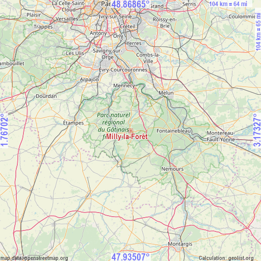
Milly-la-Forêt GPS coordinates[2]
48° 24' 14.4" North, 2° 28' 12.54" East
| Map corner | latitude | longitude |
|---|---|---|
| Upper-left | 48.86865°, | 1.76702° |
| Center: | 48.404°, | 2.47015° |
| Lower-right: | 47.93507°, | 3.17327° |
| Map W x H: | 103.8×103.8 km | = 64.5×64.5mi |
| max Lat: | 51.07786° ⇑33.6% North |
| Milly-la-Forêt: | 48.404° |
| min Lat: | ⇓66.4% South 41.3874° |
| min Long | Milly-la-Forêt | max Long |
| -5.08615° | 2.47015° | 9.52242° |
| W 50.1%⇐ | ⇒49.9% E |
Elevation
Elevation of Milly-la-Forêt is 67 m = 220 ft, and this is 126.7 m = 416 ft below average elevation for this country.
| Max E: |
2333 m = 7654 ft | 75% |
| Avg. | 193.7 m = 635 ft | |
| Milly-la-Forêt | 67 m = 220 ft | |
Min E: |
-1 m = -3 ft | 25% |
See also: France elevation on elevation.city.
Geographical zone
Milly-la-Forêt is located in North temperate zone (between Tropic of Cancer and the Arctic Circle). Distance of this North polar circle is 2019.2 km =1254.7 mi to North.| Distance of | km | miles | from Milly-la-Forêt |
|---|---|---|---|
| North Pole | 4625 | 2873.8 | to North |
| Arctic Circle | 2019.2 | 1254.7 | to North |
| Tropic Cancer | 2776.1 | 1725 | to South |
| Equator | 5382 | 3344.2 | to South |


Nearby cities:
15 places around Milly-la-Forêt: (largest is in red/bold)
• Arbonne-la-Forêt
7.2 km =4.5 mi,  81°
81°
• Boutigny-sur-Essonne
7.2 km =4.5 mi,  296°
296°
• Buno-Bonnevaux
8.1 km =5 mi,  229°
229°
• Cély
7.7 km =4.8 mi,  36°
36°
• Dannemois
5.6 km =3.5 mi,  6°
6°
• Fleury-en-Bière
7.4 km =4.6 mi,  51°
51°
• Gironville-sur-Essonne
7.6 km =4.7 mi,  237°
237°
• Le Vaudoué
6.3 km =3.9 mi,  145°
145°
• Maisse
6.8 km =4.2 mi,  261°
261°
• Moigny-sur-École
3.3 km =2.1 mi,  344°
344°
• Noisy-sur-École
5 km =3.1 mi, 145°
• Oncy-sur-École
2.3 km =1.4 mi,  186°
186°
• Saint-Martin-en-Bière
8 km =5 mi,  63°
63°
• Soisy-sur-École
8.2 km =5.1 mi, 11°
• Videlles
7.4 km =4.6 mi, 336°
Sources, notices
• [Note1] Compared only with cities in France existing in our database
• [Src1] Map data: © OpenStreetMap contributors (CC-BY-SA)
• [Src2] Other city data from geonames.org with taken over terms of usage.
• [Src3] Geographical zone / Annual Mean Temperature by Robert A. Rohde @ Wikipedia
