Noisy-sur-École geodata
Noisy-sur-École (Île-de-France) is a populated place; located in France in Europe/Paris (GMT+2) time zone. With population of 1,886 people, there are 5057 cities with bigger population in this country. Compared to other cities in France, 65.8% of cities are located further ↓South; 50.7% of cities are located further ←West and 70.5% of cities have higher elevation than Noisy-sur-École. Note1
Administrative division(s):
- Level 1: Île-de-France
- Level 2: Seine-et-Marne
- Level 3: Arrondissement de Fontainebleau
- Level 4: Noisy-sur-École


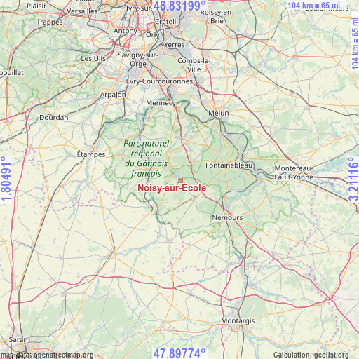
Noisy-sur-École GPS coordinates[2]
48° 22' 1.236" North, 2° 30' 28.944" East
| Map corner | latitude | longitude |
|---|---|---|
| Upper-left | 48.83199°, | 1.80491° |
| Center: | 48.36701°, | 2.50804° |
| Lower-right: | 47.89774°, | 3.21116° |
| Map W x H: | 103.9×103.9 km | = 64.6×64.6mi |
| max Lat: | 51.07786° ⇑34.2% North |
| Noisy-sur-École: | 48.36701° |
| min Lat: | ⇓65.8% South 41.3874° |
| min Long | Noisy-sur-Écol | max Long |
| -5.08615° | 2.50804° | 9.52242° |
| W 50.7%⇐ | ⇒49.3% E |
Elevation
Elevation of Noisy-sur-École is 77 m = 253 ft, and this is 116.7 m = 383 ft below average elevation for this country.
| Max E: |
2333 m = 7654 ft | 70.5% |
| Avg. | 193.7 m = 635 ft | |
| Noisy-sur-École | 77 m = 253 ft | |
Min E: |
-1 m = -3 ft | 29.5% |
See also: France elevation on elevation.city.
Geographical zone
Noisy-sur-École is located in North temperate zone (between Tropic of Cancer and the Arctic Circle). Distance of this North polar circle is 2023.3 km =1257.2 mi to North.| Distance of | km | miles | from Noisy-sur-École |
|---|---|---|---|
| North Pole | 4629.2 | 2876.5 | to North |
| Arctic Circle | 2023.3 | 1257.2 | to North |
| Tropic Cancer | 2772 | 1722.4 | to South |
| Equator | 5377.9 | 3341.7 | to South |


Nearby cities:
15 places around Noisy-sur-École: (largest is in red/bold)
• Achères-la-Forêt
4.8 km =3 mi,  106°
106°
• Arbonne-la-Forêt
6.8 km =4.2 mi,  39°
39°
• Buno-Bonnevaux
9 km =5.6 mi,  262°
262°
• Dannemois
10 km =6.2 mi,  347°
347°
• Fleury-en-Bière
9.3 km =5.8 mi,  18°
18°
• Gironville-sur-Essonne
9.2 km =5.7 mi,  269°
269°
• La Chapelle-la-Reine
7.2 km =4.5 mi,  139°
139°
• Le Vaudoué
1.4 km =0.9 mi,  145°
145°
• Maisse
10 km =6.2 mi,  288°
288°
• Milly-la-Forêt
5 km =3.1 mi,  325°
325°
• Moigny-sur-École
8.2 km =5.1 mi, 333°
• Oncy-sur-École
3.6 km =2.2 mi,  300°
300°
• Recloses
10.2 km =6.3 mi,  102°
102°
• Saint-Martin-en-Bière
8.9 km =5.5 mi,  29°
29°
• Ury
7.5 km =4.7 mi, 110°
Sources, notices
• [Note1] Compared only with cities in France existing in our database
• [Src1] Map data: © OpenStreetMap contributors (CC-BY-SA)
• [Src2] Other city data from geonames.org with taken over terms of usage.
• [Src3] Geographical zone / Annual Mean Temperature by Robert A. Rohde @ Wikipedia
