Aulnat geodata
Aulnat (Auvergne-Rhône-Alpes) is a populated place; located in France in Europe/Paris (GMT+2) time zone. With population of 4,662 people, there are 2121 cities with bigger population in this country. Compared to other cities in France, 69.3% of cities are located further ↑North; 60.1% of cities are located further ←West and 83.3% of cities have lower elevation than Aulnat. Note1
Administrative division(s):
- Level 1: Auvergne-Rhône-Alpes
- Level 2: Département du Puy-de-Dôme
- Level 3: Arrondissement de Clermont-Ferrand
- Level 4: Aulnat


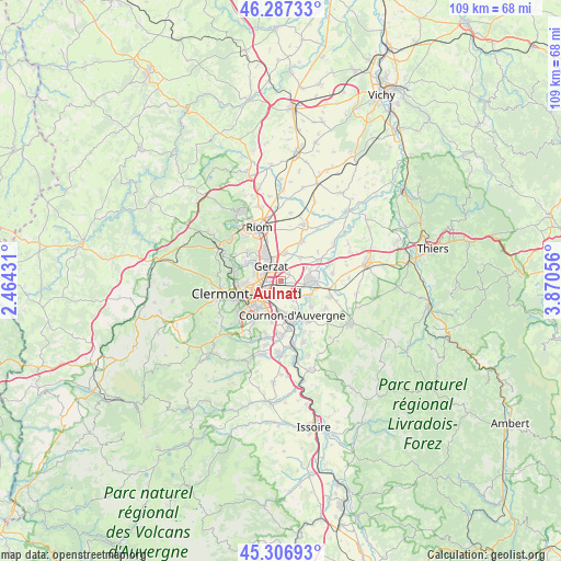
Aulnat GPS coordinates[2]
45° 47' 57.444" North, 3° 10' 2.748" East
| Map corner | latitude | longitude |
|---|---|---|
| Upper-left | 46.28733°, | 2.46431° |
| Center: | 45.79929°, | 3.16743° |
| Lower-right: | 45.30693°, | 3.87056° |
| Map W x H: | 109×109 km | = 67.7×67.7mi |
| max Lat: | 51.07786° ⇑69.3% North |
| Aulnat: | 45.79929° |
| min Lat: | ⇓30.7% South 41.3874° |
| min Long | Aulnat | max Long |
| -5.08615° | 3.16743° | 9.52242° |
| W 60.1%⇐ | ⇒39.9% E |
Elevation
Elevation of Aulnat is 325 m = 1066 ft, and this is 131.3 m = 431 ft above average elevation for this country.
| Max E: |
2333 m = 7654 ft | 16.7% |
| Aulnat | 325 m 1066 ft | |
| Avg. | 193.7 m = 635 ft | |
Min E: |
-1 m = -3 ft | 83.3% |
See also: France elevation on elevation.city.
Geographical zone
Aulnat is located in North temperate zone (between Tropic of Cancer and the Arctic Circle). Distance of this North polar circle is 2308.8 km =1434.6 mi to North.| Distance of | km | miles | from Aulnat |
|---|---|---|---|
| North Pole | 4914.7 | 3053.9 | to North |
| Arctic Circle | 2308.8 | 1434.6 | to North |
| Tropic Cancer | 2486.5 | 1545 | to South |
| Equator | 5092.4 | 3164.3 | to South |


Nearby cities:
15 places around Aulnat: (largest is in red/bold)
• Aubière
7 km =4.3 mi,  219°
219°
• Beaumont
8.4 km =5.2 mi,  231°
231°
• Blanzat
7.7 km =4.8 mi,  296°
296°
• Chamalières
8.3 km =5.2 mi,  249°
249°
• Clermont-Ferrand
6.6 km =4.1 mi, 250°
• Cournon-d’Auvergne
6.8 km =4.2 mi,  160°
160°
• Cébazat
6.3 km =3.9 mi, 304°
• Dallet
6.4 km =4 mi,  120°
120°
• Gerzat
3.4 km =2.1 mi,  329°
329°
• Lussat
5.7 km =3.5 mi,  40°
40°
• Malintrat
2.3 km =1.4 mi, 39°
• Mezel
7.6 km =4.7 mi,  130°
130°
• Pont-du-Château
6.3 km =3.9 mi,  91°
91°
• Pérignat-lès-Sarliève
7.3 km =4.5 mi,  197°
197°
• Saint-Beauzire
5.7 km =3.5 mi,  9°
9°
Sources, notices
• [Note1] Compared only with cities in France existing in our database
• [Src1] Map data: © OpenStreetMap contributors (CC-BY-SA)
• [Src2] Other city data from geonames.org with taken over terms of usage.
• [Src3] Geographical zone / Annual Mean Temperature by Robert A. Rohde @ Wikipedia
