Montagnac geodata
Montagnac (Occitanie) is a populated place; located in France in Europe/Paris (GMT+2) time zone. With population of 3,362 people, there are 2898 cities with bigger population in this country. Compared to other cities in France, 93.3% of cities are located further ↑North; 64.1% of cities are located further ←West and 82.6% of cities have higher elevation than Montagnac. Note1
Administrative division(s):
- Level 1: Occitanie
- Level 2: Département de l'Hérault
- Level 3: Arrondissement de Béziers
- Level 4: Montagnac


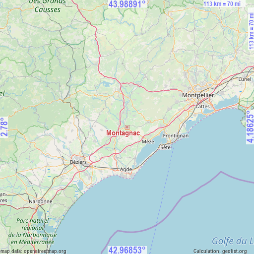
Montagnac GPS coordinates[2]
43° 28' 51.132" North, 3° 28' 59.232" East
| Map corner | latitude | longitude |
|---|---|---|
| Upper-left | 43.98891°, | 2.78° |
| Center: | 43.48087°, | 3.48312° |
| Lower-right: | 42.96853°, | 4.18625° |
| Map W x H: | 113.5×113.5 km | = 70.5×70.5mi |
| max Lat: | 51.07786° ⇑93.3% North |
| Montagnac: | 43.48087° |
| min Lat: | ⇓6.7% South 41.3874° |
| min Long | Montagnac | max Long |
| -5.08615° | 3.48312° | 9.52242° |
| W 64.1%⇐ | ⇒35.9% E |
Elevation
Elevation of Montagnac is 48 m = 157 ft, and this is 145.7 m = 478 ft below average elevation for this country.
| Max E: |
2333 m = 7654 ft | 82.6% |
| Avg. | 193.7 m = 635 ft | |
| Montagnac | 48 m = 157 ft | |
Min E: |
-1 m = -3 ft | 17.4% |
See also: France elevation on elevation.city.
Geographical zone
Montagnac is located in North temperate zone (between Tropic of Cancer and the Arctic Circle). Distance of this Northern Tropic circle is 2228.7 km =1384.8 mi to South.| Distance of | km | miles | from Montagnac |
|---|---|---|---|
| North Pole | 5172.4 | 3214 | to North |
| Arctic Circle | 2566.6 | 1594.8 | to North |
| Tropic Cancer | 2228.7 | 1384.8 | to South |
| Equator | 4834.6 | 3004.1 | to South |


Nearby cities:
15 places around Montagnac: (largest is in red/bold)
• Adissan
7.5 km =4.7 mi,  322°
322°
• Aspiran
9.8 km =6.1 mi,  344°
344°
• Castelnau-de-Guers
6.4 km =4 mi,  215°
215°
• Caux
9.8 km =6.1 mi,  286°
286°
• Lézignan-la-Cèbe
4 km =2.5 mi, 290°
• Nizas
7.1 km =4.4 mi,  300°
300°
• Paulhan
6.8 km =4.2 mi, 342°
• Pinet
8.7 km =5.4 mi,  165°
165°
• Plaissan
9.2 km =5.7 mi,  22°
22°
• Pomérols
10 km =6.2 mi, 172°
• Pézenas
5.3 km =3.3 mi,  243°
243°
• Saint-Pargoire
5.9 km =3.7 mi,  28°
28°
• Saint-Pons-de-Mauchiens
4.4 km =2.7 mi,  35°
35°
• Tourbes
9.3 km =5.8 mi,  245°
245°
• Villeveyrac
10.3 km =6.4 mi,  77°
77°
Sources, notices
• [Note1] Compared only with cities in France existing in our database
• [Src1] Map data: © OpenStreetMap contributors (CC-BY-SA)
• [Src2] Other city data from geonames.org with taken over terms of usage.
• [Src3] Geographical zone / Annual Mean Temperature by Robert A. Rohde @ Wikipedia
