Saint-Pons-de-Mauchiens geodata
Saint-Pons-de-Mauchiens (Occitanie) is a populated place; located in France in Europe/Paris (GMT+2) time zone. With population of 560 people, there are 14001 cities with bigger population in this country. Compared to other cities in France, 92.9% of cities are located further ↑North; 64.4% of cities are located further ←West and 59.4% of cities have higher elevation than Saint-Pons-de-Mauchiens. Note1
Administrative division(s):
- Level 1: Occitanie
- Level 2: Département de l'Hérault
- Level 3: Arrondissement de Béziers
- Level 4: Saint-Pons-de-Mauchiens
Current local time in Saint-Pons-de-Mauchiens:
09:57 AM, SundayDifference from your time zone: hours


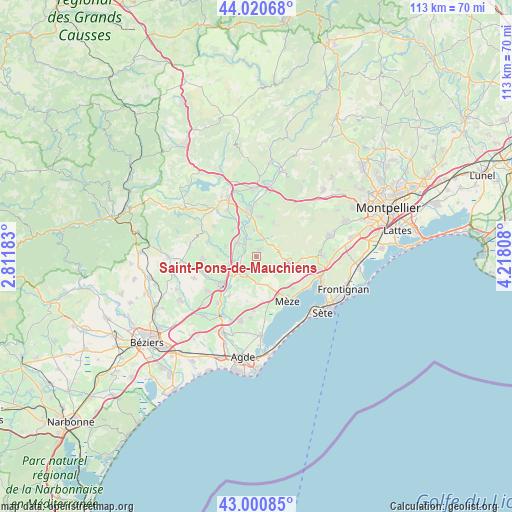
Saint-Pons-de-Mauchiens GPS coordinates[2]
43° 30' 46.512" North, 3° 30' 53.82" East
| Map corner | latitude | longitude |
|---|---|---|
| Upper-left | 44.02068°, | 2.81183° |
| Center: | 43.51292°, | 3.51495° |
| Lower-right: | 43.00085°, | 4.21808° |
| Map W x H: | 113.4×113.4 km | = 70.5×70.5mi |
| max Lat: | 51.07786° ⇑92.9% North |
| Saint-Pons-de-Mauchiens: | 43.51292° |
| min Lat: | ⇓7.1% South 41.3874° |
| min Long | Saint-Pons-de-M | max Long |
| -5.08615° | 3.51495° | 9.52242° |
| W 64.4%⇐ | ⇒35.6% E |
Elevation
Elevation of Saint-Pons-de-Mauchiens is 104 m = 341 ft, and this is 89.7 m = 294 ft below average elevation for this country.
| Max E: |
2333 m = 7654 ft | 59.4% |
| Avg. | 193.7 m = 635 ft | |
| Saint-Pons-de-Mauchiens | 104 m = 341 ft | |
Min E: |
-1 m = -3 ft | 40.6% |
See also: France elevation on elevation.city.
Geographical zone
Saint-Pons-de-Mauchiens is located in North temperate zone (between Tropic of Cancer and the Arctic Circle). Distance of this Northern Tropic circle is 2232.3 km =1387.1 mi to South.| Distance of | km | miles | from Saint-Pons-de-Mauchiens |
|---|---|---|---|
| North Pole | 5168.9 | 3211.8 | to North |
| Arctic Circle | 2563 | 1592.6 | to North |
| Tropic Cancer | 2232.3 | 1387.1 | to South |
| Equator | 4838.2 | 3006.3 | to South |


Nearby cities:
15 places around Saint-Pons-de-Mauchiens: (largest is in red/bold)
• Adissan
7.5 km =4.7 mi,  288°
288°
• Aspiran
7.9 km =4.9 mi,  318°
318°
• Castelnau-de-Guers
10.8 km =6.7 mi,  215°
215°
• Fontès
11.3 km =7 mi, 285°
• Le Pouget
8.8 km =5.5 mi,  4°
4°
• Loupian
10.7 km =6.6 mi,  131°
131°
• Lézignan-la-Cèbe
6.6 km =4.1 mi,  251°
251°
• Montagnac
4.4 km =2.7 mi, 215°
• Nizas
8.6 km =5.3 mi,  270°
270°
• Paulhan
5.5 km =3.4 mi,  302°
302°
• Plaissan
5 km =3.1 mi,  10°
10°
• Pézenas
9.4 km =5.8 mi,  231°
231°
• Saint-Pargoire
1.7 km =1.1 mi, 10°
• Vendémian
8.4 km =5.2 mi,  26°
26°
• Villeveyrac
7.6 km =4.7 mi,  100°
100°
Sources, notices
• [Note1] Compared only with cities in France existing in our database
• [Src1] Map data: © OpenStreetMap contributors (CC-BY-SA)
• [Src2] Other city data from geonames.org with taken over terms of usage.
• [Src3] Geographical zone / Annual Mean Temperature by Robert A. Rohde @ Wikipedia
