Mers-sur-Indre geodata
Mers-sur-Indre (Centre) is a populated place; located in France in Europe/Paris (GMT+2) time zone. With population of 603 people, there are 13268 cities with bigger population in this country. Compared to other cities in France, 58.7% of cities are located further ↑North; 58.5% of cities are located further →East and 61.6% of cities have lower elevation than Mers-sur-Indre. Note1
Administrative division(s):
- Level 1: Centre
- Level 2: Département de l'Indre
- Level 3: Arrondissement de La Châtre
- Level 4: Mers-sur-Indre


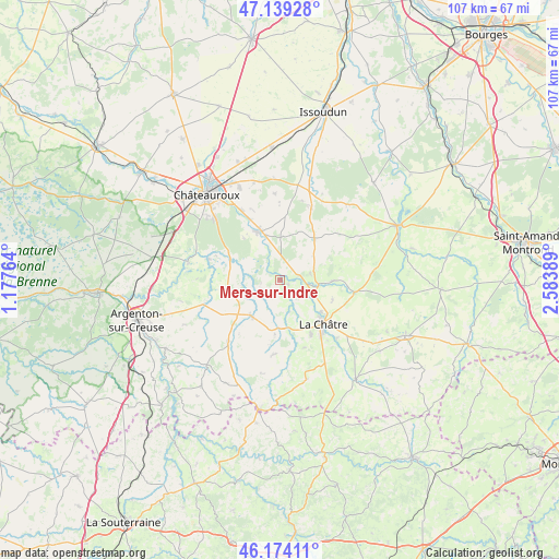
Mers-sur-Indre GPS coordinates[2]
46° 39' 31.86" North, 1° 52' 50.736" East
| Map corner | latitude | longitude |
|---|---|---|
| Upper-left | 47.13928°, | 1.17764° |
| Center: | 46.65885°, | 1.88076° |
| Lower-right: | 46.17411°, | 2.58389° |
| Map W x H: | 107.3×107.3 km | = 66.7×66.7mi |
| max Lat: | 51.07786° ⇑58.7% North |
| Mers-sur-Indre: | 46.65885° |
| min Lat: | ⇓41.3% South 41.3874° |
| min Long | Mers-sur-Indre | max Long |
| -5.08615° | 1.88076° | 9.52242° |
| W 41.5%⇐ | ⇒58.5% E |
Elevation
Elevation of Mers-sur-Indre is 178 m = 584 ft, and this is 15.7 m = 52 ft below average elevation for this country.
| Max E: |
2333 m = 7654 ft | 38.4% |
| Avg. | 193.7 m = 635 ft | |
| Mers-sur-Indre | 178 m = 584 ft | |
Min E: |
-1 m = -3 ft | 61.6% |
See also: France elevation on elevation.city.
Geographical zone
Mers-sur-Indre is located in North temperate zone (between Tropic of Cancer and the Arctic Circle). Distance of this North polar circle is 2213.2 km =1375.2 mi to North.| Distance of | km | miles | from Mers-sur-Indre |
|---|---|---|---|
| North Pole | 4819.1 | 2994.4 | to North |
| Arctic Circle | 2213.2 | 1375.2 | to North |
| Tropic Cancer | 2582.1 | 1604.4 | to South |
| Equator | 5188 | 3223.7 | to South |


Nearby cities:
15 places around Mers-sur-Indre: (largest is in red/bold)
• Ambrault
15.1 km =9.4 mi,  23°
23°
• Ardentes
9.9 km =6.2 mi,  339°
339°
• Arthon
14.4 km =8.9 mi,  285°
285°
• Briantes
15.6 km =9.7 mi,  136°
136°
• Chassignolles
13.8 km =8.6 mi,  161°
161°
• Cluis
16.2 km =10.1 mi,  218°
218°
• La Châtre
11.8 km =7.3 mi, 136°
• Lacs
13.7 km =8.5 mi,  126°
126°
• Le Magny
11.6 km =7.2 mi,  150°
150°
• Montgivray
9.9 km =6.2 mi, 128°
• Montipouret
1.8 km =1.1 mi,  123°
123°
• Neuvy-Saint-Sépulchre
8.9 km =5.5 mi, 220°
• Saint-Août
10.3 km =6.4 mi,  38°
38°
• Saint-Chartier
7.5 km =4.7 mi,  98°
98°
• Étrechet
15.3 km =9.5 mi,  331°
331°
Sources, notices
• [Note1] Compared only with cities in France existing in our database
• [Src1] Map data: © OpenStreetMap contributors (CC-BY-SA)
• [Src2] Other city data from geonames.org with taken over terms of usage.
• [Src3] Geographical zone / Annual Mean Temperature by Robert A. Rohde @ Wikipedia
