Ardentes geodata
Ardentes (Centre) is a populated place; located in France in Europe/Paris (GMT+2) time zone. With population of 3,356 people, there are 2908 cities with bigger population in this country. Compared to other cities in France, 57.8% of cities are located further ↑North; 59% of cities are located further →East and 58.7% of cities have lower elevation than Ardentes. Note1
Administrative division(s):
- Level 1: Centre
- Level 2: Département de l'Indre
- Level 3: Arrondissement de Châteauroux
- Level 4: Ardentes


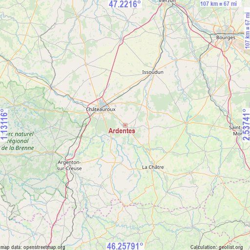
Ardentes GPS coordinates[2]
46° 44' 30.876" North, 1° 50' 3.408" East
| Map corner | latitude | longitude |
|---|---|---|
| Upper-left | 47.2216°, | 1.13116° |
| Center: | 46.74191°, | 1.83428° |
| Lower-right: | 46.25791°, | 2.53741° |
| Map W x H: | 107.2×107.2 km | = 66.6×66.6mi |
| max Lat: | 51.07786° ⇑57.8% North |
| Ardentes: | 46.74191° |
| min Lat: | ⇓42.2% South 41.3874° |
| min Long | Ardentes | max Long |
| -5.08615° | 1.83428° | 9.52242° |
| W 41%⇐ | ⇒59% E |
Elevation
Elevation of Ardentes is 164 m = 538 ft, and this is 29.7 m = 97 ft below average elevation for this country.
| Max E: |
2333 m = 7654 ft | 41.3% |
| Avg. | 193.7 m = 635 ft | |
| Ardentes | 164 m = 538 ft | |
Min E: |
-1 m = -3 ft | 58.7% |
See also: France elevation on elevation.city.
Geographical zone
Ardentes is located in North temperate zone (between Tropic of Cancer and the Arctic Circle). Distance of this North polar circle is 2204 km =1369.5 mi to North.| Distance of | km | miles | from Ardentes |
|---|---|---|---|
| North Pole | 4809.8 | 2988.7 | to North |
| Arctic Circle | 2204 | 1369.5 | to North |
| Tropic Cancer | 2591.3 | 1610.2 | to South |
| Equator | 5197.2 | 3229.4 | to South |


Nearby cities:
15 places around Ardentes: (largest is in red/bold)
• Ambrault
10.6 km =6.6 mi,  63°
63°
• Arthon
11.7 km =7.3 mi,  242°
242°
• Châteauroux
13.3 km =8.3 mi,  306°
306°
• Diors
9.5 km =5.9 mi,  357°
357°
• Déols
13.9 km =8.6 mi, 314°
• Le Poinçonnet
9.2 km =5.7 mi,  285°
285°
• Mers-sur-Indre
9.9 km =6.2 mi,  159°
159°
• Montierchaume
14.3 km =8.9 mi,  340°
340°
• Montipouret
11.4 km =7.1 mi,  153°
153°
• Mâron
7.7 km =4.8 mi,  16°
16°
• Neuvy-Pailloux
16 km =9.9 mi,  7°
7°
• Saint-Août
10.1 km =6.3 mi,  96°
96°
• Saint-Chartier
15 km =9.3 mi,  133°
133°
• Velles
15.3 km =9.5 mi,  247°
247°
• Étrechet
5.7 km =3.5 mi,  317°
317°
Sources, notices
• [Note1] Compared only with cities in France existing in our database
• [Src1] Map data: © OpenStreetMap contributors (CC-BY-SA)
• [Src2] Other city data from geonames.org with taken over terms of usage.
• [Src3] Geographical zone / Annual Mean Temperature by Robert A. Rohde @ Wikipedia
