Saint-Août geodata
Saint-Août (Centre) is a populated place; located in France in Europe/Paris (GMT+2) time zone. With population of 813 people, there are 10450 cities with bigger population in this country. Compared to other cities in France, 57.9% of cities are located further ↑North; 57.6% of cities are located further →East and 65% of cities have lower elevation than Saint-Août. Note1
Administrative division(s):
- Level 1: Centre
- Level 2: Département de l'Indre
- Level 3: Arrondissement de La Châtre
- Level 4: Saint-Août


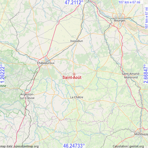
Saint-Août GPS coordinates[2]
46° 43' 53.112" North, 1° 57' 55.224" East
| Map corner | latitude | longitude |
|---|---|---|
| Upper-left | 47.2112°, | 1.26222° |
| Center: | 46.73142°, | 1.96534° |
| Lower-right: | 46.24733°, | 2.66847° |
| Map W x H: | 107.2×107.2 km | = 66.6×66.6mi |
| max Lat: | 51.07786° ⇑57.9% North |
| Saint-Août: | 46.73142° |
| min Lat: | ⇓42.1% South 41.3874° |
| min Long | Saint-Août | max Long |
| -5.08615° | 1.96534° | 9.52242° |
| W 42.4%⇐ | ⇒57.6% E |
Elevation
Elevation of Saint-Août is 194 m = 636 ft, and this is 0.30000000000001 m = 1 ft above average elevation for this country.
| Max E: |
2333 m = 7654 ft | 35% |
| Saint-Août | 194 m 636 ft | |
| Avg. | 193.7 m = 635 ft | |
Min E: |
-1 m = -3 ft | 65% |
See also: France elevation on elevation.city.
Geographical zone
Saint-Août is located in North temperate zone (between Tropic of Cancer and the Arctic Circle). Distance of this North polar circle is 2205.1 km =1370.2 mi to North.| Distance of | km | miles | from Saint-Août |
|---|---|---|---|
| North Pole | 4811 | 2989.4 | to North |
| Arctic Circle | 2205.1 | 1370.2 | to North |
| Tropic Cancer | 2590.1 | 1609.4 | to South |
| Equator | 5196 | 3228.6 | to South |


Nearby cities:
15 places around Saint-Août: (largest is in red/bold)
• Ambrault
5.8 km =3.6 mi,  355°
355°
• Ardentes
10.1 km =6.3 mi,  276°
276°
• Chezal-Benoît
15.3 km =9.5 mi,  47°
47°
• Diors
14.9 km =9.3 mi,  315°
315°
• La Châtre
16.7 km =10.4 mi,  174°
174°
• Lacs
16.8 km =10.4 mi,  164°
164°
• Lignières
16 km =9.9 mi,  81°
81°
• Mers-sur-Indre
10.3 km =6.4 mi,  218°
218°
• Montgivray
14.3 km =8.9 mi,  175°
175°
• Montipouret
10.3 km =6.4 mi,  208°
208°
• Mâron
11.5 km =7.1 mi, 317°
• Pruniers
9.1 km =5.7 mi, 45°
• Saint-Chartier
9.2 km =5.7 mi, 174°
• Saint-Hilaire-en-Lignières
15.8 km =9.8 mi,  92°
92°
• Étrechet
14.8 km =9.2 mi,  291°
291°
Sources, notices
• [Note1] Compared only with cities in France existing in our database
• [Src1] Map data: © OpenStreetMap contributors (CC-BY-SA)
• [Src2] Other city data from geonames.org with taken over terms of usage.
• [Src3] Geographical zone / Annual Mean Temperature by Robert A. Rohde @ Wikipedia
