Mérigny geodata
Mérigny (Centre) is a populated place; located in France in Europe/Paris (GMT+2) time zone. With population of 570 people, there are 13826 cities with bigger population in this country. Compared to other cities in France, 58.9% of cities are located further ↑North; 69.5% of cities are located further →East and 68.3% of cities have higher elevation than Mérigny. Note1
Administrative division(s):
- Level 1: Centre
- Level 2: Département de l'Indre
- Level 3: Le Blanc
- Level 4: Mérigny


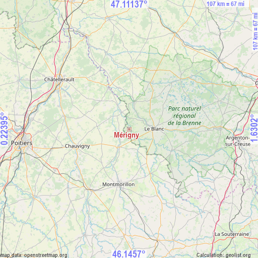
Mérigny GPS coordinates[2]
46° 37' 50.484" North, 0° 55' 37.488" East
| Map corner | latitude | longitude |
|---|---|---|
| Upper-left | 47.11137°, | 0.22395° |
| Center: | 46.63069°, | 0.92708° |
| Lower-right: | 46.1457°, | 1.6302° |
| Map W x H: | 107.4×107.4 km | = 66.7×66.7mi |
| max Lat: | 51.07786° ⇑58.9% North |
| Mérigny: | 46.63069° |
| min Lat: | ⇓41.1% South 41.3874° |
| min Long | Mérigny | max Long |
| -5.08615° | 0.92708° | 9.52242° |
| W 30.5%⇐ | ⇒69.5% E |
Elevation
Elevation of Mérigny is 82 m = 269 ft, and this is 111.7 m = 366 ft below average elevation for this country.
| Max E: |
2333 m = 7654 ft | 68.3% |
| Avg. | 193.7 m = 635 ft | |
| Mérigny | 82 m = 269 ft | |
Min E: |
-1 m = -3 ft | 31.7% |
See also: France elevation on elevation.city.
Geographical zone
Mérigny is located in North temperate zone (between Tropic of Cancer and the Arctic Circle). Distance of this North polar circle is 2216.3 km =1377.1 mi to North.| Distance of | km | miles | from Mérigny |
|---|---|---|---|
| North Pole | 4822.2 | 2996.4 | to North |
| Arctic Circle | 2216.3 | 1377.1 | to North |
| Tropic Cancer | 2578.9 | 1602.5 | to South |
| Equator | 5184.8 | 3221.7 | to South |


Nearby cities:
15 places around Mérigny: (largest is in red/bold)
• Antigny
12 km =7.5 mi,  207°
207°
• Béthines
10 km =6.2 mi,  158°
158°
• Concremiers
7.8 km =4.8 mi,  118°
118°
• La Puye
13.5 km =8.4 mi,  275°
275°
• Le Blanc
10.4 km =6.5 mi,  88°
88°
• Leignes-sur-Fontaine
18 km =11.2 mi,  219°
219°
• Pleumartin
17.1 km =10.6 mi,  314°
314°
• Pouligny-Saint-Pierre
10.2 km =6.3 mi,  56°
56°
• Saint-Germain
8.5 km =5.3 mi, 208°
• Saint-Pierre-de-Maillé
8.4 km =5.2 mi, 309°
• Saint-Savin
8.7 km =5.4 mi, 213°
• Tournon-Saint-Martin
11.7 km =7.3 mi,  10°
10°
• Tournon-Saint-Pierre
12.2 km =7.6 mi, 9°
• Vicq-sur-Gartempe
11.2 km =7 mi,  333°
333°
• Yzeures-sur-Creuse
17.8 km =11.1 mi,  346°
346°
Sources, notices
• [Note1] Compared only with cities in France existing in our database
• [Src1] Map data: © OpenStreetMap contributors (CC-BY-SA)
• [Src2] Other city data from geonames.org with taken over terms of usage.
• [Src3] Geographical zone / Annual Mean Temperature by Robert A. Rohde @ Wikipedia
