Saint-Savin geodata
Saint-Savin (Nouvelle-Aquitaine) is a populated place; located in France in Europe/Paris (GMT+2) time zone. With population of 1,070 people, there are 8333 cities with bigger population in this country. Compared to other cities in France, 59.6% of cities are located further ↑North; 70% of cities are located further →East and 69.2% of cities have higher elevation than Saint-Savin. Note1
Administrative division(s):
- Level 1: Nouvelle-Aquitaine
- Level 2: Vienne
- Level 3: Arrondissement de Montmorillon
- Level 4: Saint-Savin


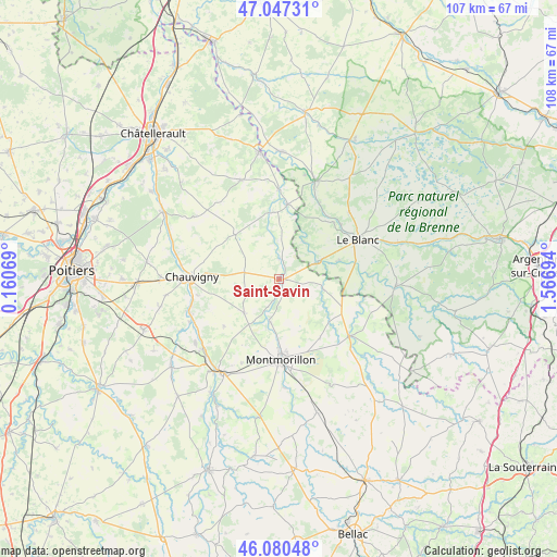
Saint-Savin GPS coordinates[2]
46° 33' 57.78" North, 0° 51' 49.716" East
| Map corner | latitude | longitude |
|---|---|---|
| Upper-left | 47.04731°, | 0.16069° |
| Center: | 46.56605°, | 0.86381° |
| Lower-right: | 46.08048°, | 1.56694° |
| Map W x H: | 107.5×107.5 km | = 66.8×66.8mi |
| max Lat: | 51.07786° ⇑59.6% North |
| Saint-Savin: | 46.56605° |
| min Lat: | ⇓40.4% South 41.3874° |
| min Long | Saint-Savin | max Long |
| -5.08615° | 0.86381° | 9.52242° |
| W 30%⇐ | ⇒70% E |
Elevation
Elevation of Saint-Savin is 80 m = 262 ft, and this is 113.7 m = 373 ft below average elevation for this country.
| Max E: |
2333 m = 7654 ft | 69.2% |
| Avg. | 193.7 m = 635 ft | |
| Saint-Savin | 80 m = 262 ft | |
Min E: |
-1 m = -3 ft | 30.8% |
See also: France elevation on elevation.city.
Geographical zone
Saint-Savin is located in North temperate zone (between Tropic of Cancer and the Arctic Circle). Distance of this North polar circle is 2223.5 km =1381.6 mi to North.| Distance of | km | miles | from Saint-Savin |
|---|---|---|---|
| North Pole | 4829.4 | 3000.8 | to North |
| Arctic Circle | 2223.5 | 1381.6 | to North |
| Tropic Cancer | 2571.7 | 1598 | to South |
| Equator | 5177.7 | 3217.3 | to South |


Nearby cities:
15 places around Saint-Savin: (largest is in red/bold)
• Antigny
3.5 km =2.2 mi,  192°
192°
• Béthines
8.8 km =5.5 mi,  103°
103°
• Chauvigny
16.8 km =10.4 mi,  271°
271°
• Concremiers
12.2 km =7.6 mi,  73°
73°
• La Puye
12.1 km =7.5 mi,  314°
314°
• La Trimouille
17.4 km =10.8 mi,  129°
129°
• Le Blanc
17 km =10.6 mi,  63°
63°
• Leignes-sur-Fontaine
9.5 km =5.9 mi,  225°
225°
• Montmorillon
15.5 km =9.6 mi,  178°
178°
• Mérigny
8.7 km =5.4 mi,  33°
33°
• Pouligny-Saint-Pierre
18.5 km =11.5 mi,  46°
46°
• Saint-Germain
0.8 km =0.5 mi,  109°
109°
• Saint-Pierre-de-Maillé
12.7 km =7.9 mi,  352°
352°
• Sillars
17.8 km =11.1 mi,  204°
204°
• Vicq-sur-Gartempe
17.3 km =10.7 mi,  359°
359°
Sources, notices
• [Note1] Compared only with cities in France existing in our database
• [Src1] Map data: © OpenStreetMap contributors (CC-BY-SA)
• [Src2] Other city data from geonames.org with taken over terms of usage.
• [Src3] Geographical zone / Annual Mean Temperature by Robert A. Rohde @ Wikipedia
