Mecé geodata
Mecé (Brittany) is a populated place; located in France in Europe/Paris (GMT+2) time zone. With population of 509 people, there are 15057 cities with bigger population in this country. Compared to other cities in France, 63.5% of cities are located further ↓South; 90.8% of cities are located further →East and 54.4% of cities have higher elevation than Mecé. Note1
Administrative division(s):
- Level 1: Brittany
- Level 2: Département d'Ille-et-Vilaine
- Level 3: Arrondissement de Fougères-Vitré
- Level 4: Mecé


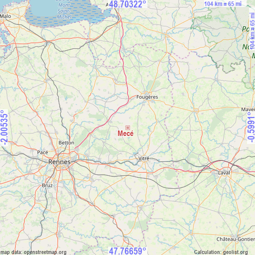
Mecé GPS coordinates[2]
48° 14' 13.38" North, 1° 18' 7.992" West
| Map corner | latitude | longitude |
|---|---|---|
| Upper-left | 48.70322°, | -2.00535° |
| Center: | 48.23705°, | -1.30222° |
| Lower-right: | 47.76659°, | -0.5991° |
| Map W x H: | 104.1×104.1 km | = 64.7×64.7mi |
| max Lat: | 51.07786° ⇑36.5% North |
| Mecé: | 48.23705° |
| min Lat: | ⇓63.5% South 41.3874° |
| min Long | Mecé | max Long |
| -5.08615° | -1.30222° | 9.52242° |
| W 9.2%⇐ | ⇒90.8% E |
Elevation
Elevation of Mecé is 118 m = 387 ft, and this is 75.7 m = 248 ft below average elevation for this country.
| Max E: |
2333 m = 7654 ft | 54.4% |
| Avg. | 193.7 m = 635 ft | |
| Mecé | 118 m = 387 ft | |
Min E: |
-1 m = -3 ft | 45.6% |
See also: France elevation on elevation.city.
Geographical zone
Mecé is located in North temperate zone (between Tropic of Cancer and the Arctic Circle). Distance of this North polar circle is 2037.7 km =1266.2 mi to North.| Distance of | km | miles | from Mecé |
|---|---|---|---|
| North Pole | 4643.6 | 2885.4 | to North |
| Arctic Circle | 2037.7 | 1266.2 | to North |
| Tropic Cancer | 2757.5 | 1713.4 | to South |
| Equator | 5363.5 | 3332.7 | to South |


Nearby cities:
15 places around Mecé: (largest is in red/bold)
• Balazé
11.2 km =7 mi,  133°
133°
• Billé
7 km =4.3 mi,  36°
36°
• Châtillon-en-Vendelais
9.4 km =5.8 mi,  98°
98°
• Dourdain
7 km =4.3 mi,  225°
225°
• Javené
11.1 km =6.9 mi,  34°
34°
• La Bouëxière
11.4 km =7.1 mi,  238°
238°
• Livré-sur-Changeon
3.7 km =2.3 mi, 237°
• Marpiré
10.9 km =6.8 mi,  194°
194°
• Montreuil-sous-Pérouse
10.6 km =6.6 mi,  153°
153°
• Parcé
8.5 km =5.3 mi,  61°
61°
• Romagné
11.6 km =7.2 mi,  9°
9°
• Saint-Aubin-du-Cormier
7.8 km =4.8 mi,  287°
287°
• Saint-Christophe-des-Bois
4.3 km =2.7 mi,  106°
106°
• Saint-Jean-sur-Couesnon
7.7 km =4.8 mi,  320°
320°
• Taillis
7.2 km =4.5 mi,  138°
138°
Sources, notices
• [Note1] Compared only with cities in France existing in our database
• [Src1] Map data: © OpenStreetMap contributors (CC-BY-SA)
• [Src2] Other city data from geonames.org with taken over terms of usage.
• [Src3] Geographical zone / Annual Mean Temperature by Robert A. Rohde @ Wikipedia
