Livré-sur-Changeon geodata
Livré-sur-Changeon (Brittany) is a populated place; located in France in Europe/Paris (GMT+2) time zone. With population of 1,366 people, there are 6739 cities with bigger population in this country. Compared to other cities in France, 63.1% of cities are located further ↓South; 91.1% of cities are located further →East and 54.8% of cities have higher elevation than Livré-sur-Changeon. Note1
Administrative division(s):
- Level 1: Brittany
- Level 2: Département d'Ille-et-Vilaine
- Level 3: Arrondissement de Rennes
- Level 4: Livré-sur-Changeon


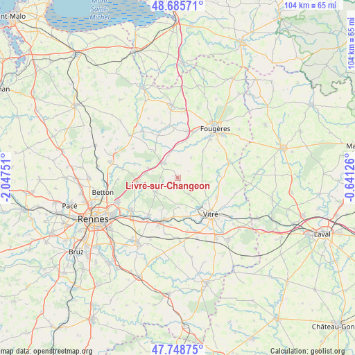
Livré-sur-Changeon GPS coordinates[2]
48° 13' 9.732" North, 1° 20' 39.768" West
| Map corner | latitude | longitude |
|---|---|---|
| Upper-left | 48.68571°, | -2.04751° |
| Center: | 48.21937°, | -1.34438° |
| Lower-right: | 47.74875°, | -0.64126° |
| Map W x H: | 104.2×104.2 km | = 64.7×64.7mi |
| max Lat: | 51.07786° ⇑36.9% North |
| Livré-sur-Changeon: | 48.21937° |
| min Lat: | ⇓63.1% South 41.3874° |
| min Long | Livré-sur-Chan | max Long |
| -5.08615° | -1.34438° | 9.52242° |
| W 8.9%⇐ | ⇒91.1% E |
Elevation
Elevation of Livré-sur-Changeon is 117 m = 384 ft, and this is 76.7 m = 252 ft below average elevation for this country.
| Max E: |
2333 m = 7654 ft | 54.8% |
| Avg. | 193.7 m = 635 ft | |
| Livré-sur-Changeon | 117 m = 384 ft | |
Min E: |
-1 m = -3 ft | 45.2% |
See also: France elevation on elevation.city.
Geographical zone
Livré-sur-Changeon is located in North temperate zone (between Tropic of Cancer and the Arctic Circle). Distance of this North polar circle is 2039.7 km =1267.4 mi to North.| Distance of | km | miles | from Livré-sur-Changeon |
|---|---|---|---|
| North Pole | 4645.6 | 2886.6 | to North |
| Arctic Circle | 2039.7 | 1267.4 | to North |
| Tropic Cancer | 2755.6 | 1712.2 | to South |
| Equator | 5361.5 | 3331.5 | to South |


Nearby cities:
15 places around Livré-sur-Changeon: (largest is in red/bold)
• Billé
10.5 km =6.5 mi,  43°
43°
• Dourdain
3.5 km =2.2 mi,  213°
213°
• Gosné
9.5 km =5.9 mi,  288°
288°
• La Bouëxière
7.7 km =4.8 mi,  238°
238°
• Liffré
12.2 km =7.6 mi,  266°
266°
• Marpiré
8.6 km =5.3 mi,  177°
177°
• Mecé
3.7 km =2.3 mi,  57°
57°
• Montreuil-sous-Pérouse
10.8 km =6.7 mi,  134°
134°
• Mézières-sur-Couesnon
10.7 km =6.6 mi,  322°
322°
• Parcé
12.2 km =7.6 mi, 60°
• Saint-Aubin-du-Cormier
6.1 km =3.8 mi, 315°
• Saint-Christophe-des-Bois
7.3 km =4.5 mi,  84°
84°
• Saint-Jean-sur-Couesnon
8.1 km =5 mi,  347°
347°
• Saint-Jean-sur-Vilaine
11.5 km =7.1 mi,  186°
186°
• Taillis
8.6 km =5.3 mi,  113°
113°
Sources, notices
• [Note1] Compared only with cities in France existing in our database
• [Src1] Map data: © OpenStreetMap contributors (CC-BY-SA)
• [Src2] Other city data from geonames.org with taken over terms of usage.
• [Src3] Geographical zone / Annual Mean Temperature by Robert A. Rohde @ Wikipedia
