Châtillon-en-Vendelais geodata
Châtillon-en-Vendelais (Brittany) is a populated place; located in France in Europe/Paris (GMT+2) time zone. With population of 1,709 people, there are 5495 cities with bigger population in this country. Compared to other cities in France, 63.2% of cities are located further ↓South; 89.8% of cities are located further →East and 50.6% of cities have lower elevation than Châtillon-en-Vendelais. Note1
Administrative division(s):
- Level 1: Brittany
- Level 2: Département d'Ille-et-Vilaine
- Level 3: Arrondissement de Fougères-Vitré
- Level 4: Châtillon-en-Vendelais
Current local time in Châtillon-en-Vendelais:
11:22 PM, SaturdayDifference from your time zone: hours


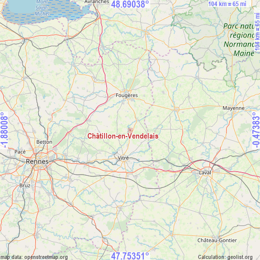
Châtillon-en-Vendelais GPS coordinates[2]
48° 13' 26.724" North, 1° 10' 37.02" West
| Map corner | latitude | longitude |
|---|---|---|
| Upper-left | 48.69038°, | -1.88008° |
| Center: | 48.22409°, | -1.17695° |
| Lower-right: | 47.75351°, | -0.47383° |
| Map W x H: | 104.2×104.2 km | = 64.7×64.7mi |
| max Lat: | 51.07786° ⇑36.8% North |
| Châtillon-en-Vendelais: | 48.22409° |
| min Lat: | ⇓63.2% South 41.3874° |
| min Long | Châtillon-en-V | max Long |
| -5.08615° | -1.17695° | 9.52242° |
| W 10.2%⇐ | ⇒89.8% E |
Elevation
Elevation of Châtillon-en-Vendelais is 134 m = 440 ft, and this is 59.7 m = 196 ft below average elevation for this country.
| Max E: |
2333 m = 7654 ft | 49.4% |
| Avg. | 193.7 m = 635 ft | |
| Châtillon-en-Vendelais | 134 m = 440 ft | |
Min E: |
-1 m = -3 ft | 50.6% |
See also: France elevation on elevation.city.
Geographical zone
Châtillon-en-Vendelais is located in North temperate zone (between Tropic of Cancer and the Arctic Circle). Distance of this North polar circle is 2039.2 km =1267.1 mi to North.| Distance of | km | miles | from Châtillon-en-Vendelais |
|---|---|---|---|
| North Pole | 4645 | 2886.3 | to North |
| Arctic Circle | 2039.2 | 1267.1 | to North |
| Tropic Cancer | 2756.1 | 1712.6 | to South |
| Equator | 5362 | 3331.8 | to South |


Nearby cities:
15 places around Châtillon-en-Vendelais: (largest is in red/bold)
• Balazé
6.3 km =3.9 mi,  189°
189°
• Billé
8.8 km =5.5 mi,  323°
323°
• Bourgon
10.4 km =6.5 mi,  127°
127°
• Dompierre-du-Chemin
5.3 km =3.3 mi,  29°
29°
• Javené
11 km =6.8 mi,  344°
344°
• Juvigné
10.6 km =6.6 mi,  87°
87°
• La Croixille
9.1 km =5.7 mi,  103°
103°
• La Selle-en-Luitré
10.3 km =6.4 mi,  20°
20°
• Luitré
7.8 km =4.8 mi, 33°
• Mecé
9.4 km =5.8 mi,  278°
278°
• Montreuil-sous-Pérouse
9.3 km =5.8 mi,  209°
209°
• Parcé
5.7 km =3.5 mi, 342°
• Saint-Christophe-des-Bois
5.2 km =3.2 mi,  272°
272°
• Taillis
6 km =3.7 mi,  228°
228°
• Vitré
12 km =7.5 mi, 190°
Sources, notices
• [Note1] Compared only with cities in France existing in our database
• [Src1] Map data: © OpenStreetMap contributors (CC-BY-SA)
• [Src2] Other city data from geonames.org with taken over terms of usage.
• [Src3] Geographical zone / Annual Mean Temperature by Robert A. Rohde @ Wikipedia
