Flagnac geodata
Flagnac (Occitanie) is a populated place; located in France in Europe/Paris (GMT+2) time zone. With population of 942 people, there are 9275 cities with bigger population in this country. Compared to other cities in France, 82.8% of cities are located further ↑North; 53.6% of cities are located further →East and 73.2% of cities have lower elevation than Flagnac. Note1
Administrative division(s):
- Level 1: Occitanie
- Level 2: Département de l'Aveyron
- Level 3: Arrondissement de Villefranche-de-Rouergue
- Level 4: Flagnac


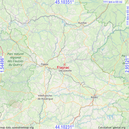
Flagnac GPS coordinates[2]
44° 36' 18.252" North, 2° 14' 53.088" East
| Map corner | latitude | longitude |
|---|---|---|
| Upper-left | 45.10351°, | 1.54496° |
| Center: | 44.60507°, | 2.24808° |
| Lower-right: | 44.10231°, | 2.95121° |
| Map W x H: | 111.3×111.3 km | = 69.2×69.2mi |
| max Lat: | 51.07786° ⇑82.8% North |
| Flagnac: | 44.60507° |
| min Lat: | ⇓17.2% South 41.3874° |
| min Long | Flagnac | max Long |
| -5.08615° | 2.24808° | 9.52242° |
| W 46.4%⇐ | ⇒53.6% E |
Elevation
Elevation of Flagnac is 237 m = 778 ft, and this is 43.3 m = 142 ft above average elevation for this country.
| Max E: |
2333 m = 7654 ft | 26.8% |
| Flagnac | 237 m 778 ft | |
| Avg. | 193.7 m = 635 ft | |
Min E: |
-1 m = -3 ft | 73.2% |
See also: France elevation on elevation.city.
Geographical zone
Flagnac is located in North temperate zone (between Tropic of Cancer and the Arctic Circle). Distance of this Northern Tropic circle is 2353.7 km =1462.5 mi to South.| Distance of | km | miles | from Flagnac |
|---|---|---|---|
| North Pole | 5047.4 | 3136.3 | to North |
| Arctic Circle | 2441.6 | 1517.1 | to North |
| Tropic Cancer | 2353.7 | 1462.5 | to South |
| Equator | 4959.6 | 3081.8 | to South |


Nearby cities:
15 places around Flagnac: (largest is in red/bold)
• Aubin
8.6 km =5.3 mi,  181°
181°
• Auzits
12.7 km =7.9 mi,  149°
149°
• Bagnac-sur-Célé
9.4 km =5.8 mi,  316°
316°
• Boisse-Penchot
3.5 km =2.2 mi,  246°
246°
• Capdenac-Gare
13.6 km =8.5 mi,  256°
256°
• Cransac
9.4 km =5.8 mi,  162°
162°
• Decazeville
5 km =3.1 mi, 177°
• Firmi
8.5 km =5.3 mi, 146°
• Livinhac-le-Haut
2 km =1.2 mi,  222°
222°
• Maurs
12.4 km =7.7 mi,  341°
341°
• Montbazens
14.2 km =8.8 mi,  185°
185°
• Saint-Constant
9 km =5.6 mi,  351°
351°
• Saint-Santin
5.6 km =3.5 mi,  333°
333°
• Saint-Étienne-de-Maurs
12.8 km =8 mi, 345°
• Viviez
5.9 km =3.7 mi,  204°
204°
Sources, notices
• [Note1] Compared only with cities in France existing in our database
• [Src1] Map data: © OpenStreetMap contributors (CC-BY-SA)
• [Src2] Other city data from geonames.org with taken over terms of usage.
• [Src3] Geographical zone / Annual Mean Temperature by Robert A. Rohde @ Wikipedia
