Martigné-sur-Mayenne geodata
Martigné-sur-Mayenne (Pays de la Loire) is a populated place; located in France in Europe/Paris (GMT+2) time zone. With population of 1,370 people, there are 6727 cities with bigger population in this country. Compared to other cities in France, 62.9% of cities are located further ↓South; 85.2% of cities are located further →East and 58.3% of cities have lower elevation than Martigné-sur-Mayenne. Note1
Administrative division(s):
- Level 1: Pays de la Loire
- Level 2: Mayenne
- Level 3: Arrondissement de Mayenne
- Level 4: Martigné-sur-Mayenne
Current local time in Martigné-sur-Mayenne:
05:59 AM, WednesdayDifference from your time zone: hours


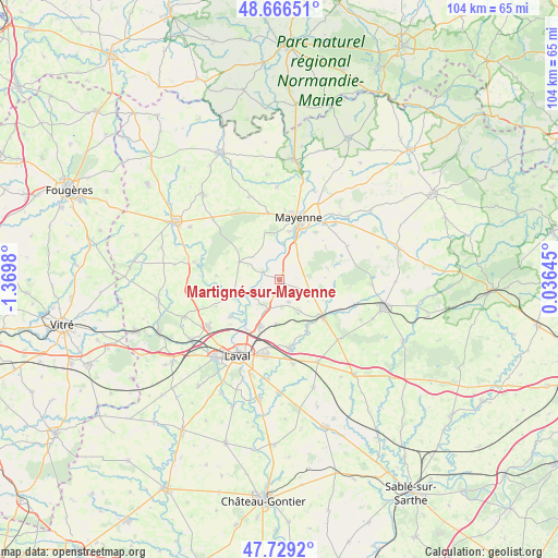
Martigné-sur-Mayenne GPS coordinates[2]
48° 12' 0" North, 0° 40' 0.012" West
| Map corner | latitude | longitude |
|---|---|---|
| Upper-left | 48.66651°, | -1.3698° |
| Center: | 48.2°, | -0.66667° |
| Lower-right: | 47.7292°, | 0.03645° |
| Map W x H: | 104.2×104.2 km | = 64.7×64.7mi |
| max Lat: | 51.07786° ⇑37.1% North |
| Martigné-sur-Mayenne: | 48.2° |
| min Lat: | ⇓62.9% South 41.3874° |
| min Long | Martigné-sur-M | max Long |
| -5.08615° | -0.66667° | 9.52242° |
| W 14.8%⇐ | ⇒85.2% E |
Elevation
Elevation of Martigné-sur-Mayenne is 162 m = 531 ft, and this is 31.7 m = 104 ft below average elevation for this country.
| Max E: |
2333 m = 7654 ft | 41.7% |
| Avg. | 193.7 m = 635 ft | |
| Martigné-sur-Mayenne | 162 m = 531 ft | |
Min E: |
-1 m = -3 ft | 58.3% |
See also: France elevation on elevation.city.
Geographical zone
Martigné-sur-Mayenne is located in North temperate zone (between Tropic of Cancer and the Arctic Circle). Distance of this North polar circle is 2041.8 km =1268.7 mi to North.| Distance of | km | miles | from Martigné-sur-Mayenne |
|---|---|---|---|
| North Pole | 4647.7 | 2887.9 | to North |
| Arctic Circle | 2041.8 | 1268.7 | to North |
| Tropic Cancer | 2753.4 | 1710.9 | to South |
| Equator | 5359.3 | 3330.1 | to South |


Nearby cities:
15 places around Martigné-sur-Mayenne: (largest is in red/bold)
• Andouillé
9 km =5.6 mi,  253°
253°
• Argentré
13.1 km =8.1 mi,  171°
171°
• Commer
5.2 km =3.2 mi,  44°
44°
• Contest
7 km =4.3 mi,  6°
6°
• La Bazoge-Montpinçon
11.1 km =6.9 mi, 38°
• La Chapelle-Anthenaise
8.6 km =5.3 mi,  185°
185°
• Louverné
9.5 km =5.9 mi,  203°
203°
• Mayenne
12.1 km =7.5 mi,  18°
18°
• Montsûrs
11 km =6.8 mi,  130°
130°
• Moulay
8.6 km =5.3 mi, 19°
• Parigné-sur-Braye
12.9 km =8 mi,  4°
4°
• Saint-Baudelle
9.2 km =5.7 mi, 13°
• Saint-Georges-Buttavent
12.4 km =7.7 mi,  350°
350°
• Saint-Germain-le-Fouilloux
11.7 km =7.3 mi,  232°
232°
• Saint-Jean-sur-Mayenne
9.8 km =6.1 mi,  222°
222°
Sources, notices
• [Note1] Compared only with cities in France existing in our database
• [Src1] Map data: © OpenStreetMap contributors (CC-BY-SA)
• [Src2] Other city data from geonames.org with taken over terms of usage.
• [Src3] Geographical zone / Annual Mean Temperature by Robert A. Rohde @ Wikipedia
