Montigny-Lencoup geodata
Montigny-Lencoup (Île-de-France) is a populated place; located in France in Europe/Paris (GMT+2) time zone. With population of 1,352 people, there are 6802 cities with bigger population in this country. Compared to other cities in France, 67.3% of cities are located further ↓South; 58.8% of cities are located further ←West and 66% of cities have higher elevation than Montigny-Lencoup. Note1
Administrative division(s):
- Level 1: Île-de-France
- Level 2: Seine-et-Marne
- Level 3: Arrondissement de Provins
- Level 4: Montigny-Lencoup


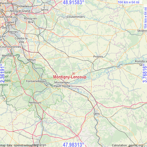
Montigny-Lencoup GPS coordinates[2]
48° 27' 5.832" North, 3° 3' 54.108" East
| Map corner | latitude | longitude |
|---|---|---|
| Upper-left | 48.91583°, | 2.36191° |
| Center: | 48.45162°, | 3.06503° |
| Lower-right: | 47.98313°, | 3.76816° |
| Map W x H: | 103.7×103.7 km | = 64.4×64.4mi |
| max Lat: | 51.07786° ⇑32.7% North |
| Montigny-Lencoup: | 48.45162° |
| min Lat: | ⇓67.3% South 41.3874° |
| min Long | Montigny-Lencou | max Long |
| -5.08615° | 3.06503° | 9.52242° |
| W 58.8%⇐ | ⇒41.2% E |
Elevation
Elevation of Montigny-Lencoup is 87 m = 285 ft, and this is 106.7 m = 350 ft below average elevation for this country.
| Max E: |
2333 m = 7654 ft | 66% |
| Avg. | 193.7 m = 635 ft | |
| Montigny-Lencoup | 87 m = 285 ft | |
Min E: |
-1 m = -3 ft | 34% |
See also: France elevation on elevation.city.
Geographical zone
Montigny-Lencoup is located in North temperate zone (between Tropic of Cancer and the Arctic Circle). Distance of this North polar circle is 2013.9 km =1251.4 mi to North.| Distance of | km | miles | from Montigny-Lencoup |
|---|---|---|---|
| North Pole | 4619.7 | 2870.5 | to North |
| Arctic Circle | 2013.9 | 1251.4 | to North |
| Tropic Cancer | 2781.4 | 1728.3 | to South |
| Equator | 5387.3 | 3347.5 | to South |


Nearby cities:
15 places around Montigny-Lencoup: (largest is in red/bold)
• Bazoches-lès-Bray
10.8 km =6.7 mi,  122°
122°
• Cannes-Écluse
11.4 km =7.1 mi,  210°
210°
• Châtenay-sur-Seine
4.3 km =2.7 mi,  149°
149°
• Donnemarie-Dontilly
5.7 km =3.5 mi,  59°
59°
• La Chapelle-Rablais
9.5 km =5.9 mi,  313°
313°
• Les Ormes-sur-Voulzie
12.2 km =7.6 mi,  83°
83°
• Marolles-sur-Seine
7.5 km =4.7 mi,  196°
196°
• Misy-sur-Yonne
10.3 km =6.4 mi,  169°
169°
• Montereau-Fault-Yonne
11.4 km =7.1 mi,  228°
228°
• Rampillon
11 km =6.8 mi,  0°
0°
• Saint-Germain-Laval
7.6 km =4.7 mi,  220°
220°
• Salins
4.6 km =2.9 mi, 223°
• Savins
11.9 km =7.4 mi, 57°
• Villeneuve-les-Bordes
3.7 km =2.3 mi,  341°
341°
• Échouboulains
8.9 km =5.5 mi,  278°
278°
Sources, notices
• [Note1] Compared only with cities in France existing in our database
• [Src1] Map data: © OpenStreetMap contributors (CC-BY-SA)
• [Src2] Other city data from geonames.org with taken over terms of usage.
• [Src3] Geographical zone / Annual Mean Temperature by Robert A. Rohde @ Wikipedia
