Châtenay-sur-Seine geodata
Châtenay-sur-Seine (Île-de-France) is a populated place; located in France in Europe/Paris (GMT+2) time zone. With population of 1,042 people, there are 8523 cities with bigger population in this country. Compared to other cities in France, 66.7% of cities are located further ↓South; 59.2% of cities are located further ←West and 81.5% of cities have higher elevation than Châtenay-sur-Seine. Note1
Administrative division(s):
- Level 1: Île-de-France
- Level 2: Seine-et-Marne
- Level 3: Arrondissement de Provins
- Level 4: Châtenay-sur-Seine


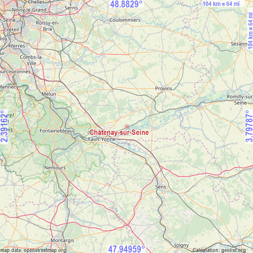
Châtenay-sur-Seine GPS coordinates[2]
48° 25' 6.204" North, 3° 5' 41.064" East
| Map corner | latitude | longitude |
|---|---|---|
| Upper-left | 48.8829°, | 2.39162° |
| Center: | 48.41839°, | 3.09474° |
| Lower-right: | 47.94959°, | 3.79787° |
| Map W x H: | 103.8×103.8 km | = 64.5×64.5mi |
| max Lat: | 51.07786° ⇑33.3% North |
| Châtenay-sur-Seine: | 48.41839° |
| min Lat: | ⇓66.7% South 41.3874° |
| min Long | Châtenay-sur-S | max Long |
| -5.08615° | 3.09474° | 9.52242° |
| W 59.2%⇐ | ⇒40.8% E |
Elevation
Elevation of Châtenay-sur-Seine is 51 m = 167 ft, and this is 142.7 m = 468 ft below average elevation for this country.
| Max E: |
2333 m = 7654 ft | 81.5% |
| Avg. | 193.7 m = 635 ft | |
| Châtenay-sur-Seine | 51 m = 167 ft | |
Min E: |
-1 m = -3 ft | 18.5% |
See also: France elevation on elevation.city.
Geographical zone
Châtenay-sur-Seine is located in North temperate zone (between Tropic of Cancer and the Arctic Circle). Distance of this North polar circle is 2017.6 km =1253.7 mi to North.| Distance of | km | miles | from Châtenay-sur-Seine |
|---|---|---|---|
| North Pole | 4623.4 | 2872.8 | to North |
| Arctic Circle | 2017.6 | 1253.7 | to North |
| Tropic Cancer | 2777.7 | 1726 | to South |
| Equator | 5383.6 | 3345.2 | to South |


Nearby cities:
15 places around Châtenay-sur-Seine: (largest is in red/bold)
• Bazoches-lès-Bray
7.2 km =4.5 mi,  107°
107°
• Cannes-Écluse
10 km =6.2 mi,  232°
232°
• Courlon-sur-Yonne
10.3 km =6.4 mi,  148°
148°
• Donnemarie-Dontilly
7.1 km =4.4 mi,  22°
22°
• La Brosse-Montceaux
9.9 km =6.2 mi,  214°
214°
• Marolles-sur-Seine
5.6 km =3.5 mi, 231°
• Misy-sur-Yonne
6.4 km =4 mi,  183°
183°
• Montigny-Lencoup
4.3 km =2.7 mi,  329°
329°
• Mousseaux-lès-Bray
9.9 km =6.2 mi,  92°
92°
• Saint-Germain-Laval
7.5 km =4.7 mi,  253°
253°
• Salins
5.4 km =3.4 mi,  273°
273°
• Villeblevin
10.5 km =6.5 mi,  185°
185°
• Villeneuve-la-Guyard
9 km =5.6 mi,  195°
195°
• Villeneuve-les-Bordes
7.9 km =4.9 mi, 334°
• Vinneuf
8.5 km =5.3 mi,  156°
156°
Sources, notices
• [Note1] Compared only with cities in France existing in our database
• [Src1] Map data: © OpenStreetMap contributors (CC-BY-SA)
• [Src2] Other city data from geonames.org with taken over terms of usage.
• [Src3] Geographical zone / Annual Mean Temperature by Robert A. Rohde @ Wikipedia
