Marmagne geodata
Marmagne (Bourgogne-Franche-Comté) is a populated place; located in France in Europe/Paris (GMT+2) time zone. With population of 1,344 people, there are 6843 cities with bigger population in this country. Compared to other cities in France, 56.8% of cities are located further ↑North; 71% of cities are located further ←West and 82.6% of cities have lower elevation than Marmagne. Note1
Administrative division(s):
- Level 1: Bourgogne-Franche-Comté
- Level 2: Département de Saône-et-Loire
- Level 3: Autun
- Level 4: Marmagne


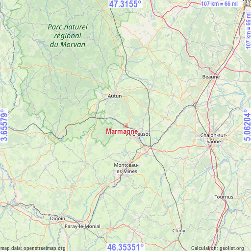
Marmagne GPS coordinates[2]
46° 50' 11.976" North, 4° 21' 32.112" East
| Map corner | latitude | longitude |
|---|---|---|
| Upper-left | 47.3155°, | 3.65579° |
| Center: | 46.83666°, | 4.35892° |
| Lower-right: | 46.35351°, | 5.06204° |
| Map W x H: | 107×107 km | = 66.5×66.5mi |
| max Lat: | 51.07786° ⇑56.8% North |
| Marmagne: | 46.83666° |
| min Lat: | ⇓43.2% South 41.3874° |
| min Long | Marmagne | max Long |
| -5.08615° | 4.35892° | 9.52242° |
| W 71%⇐ | ⇒29% E |
Elevation
Elevation of Marmagne is 317 m = 1040 ft, and this is 123.3 m = 405 ft above average elevation for this country.
| Max E: |
2333 m = 7654 ft | 17.4% |
| Marmagne | 317 m 1040 ft | |
| Avg. | 193.7 m = 635 ft | |
Min E: |
-1 m = -3 ft | 82.6% |
See also: France elevation on elevation.city.
Geographical zone
Marmagne is located in North temperate zone (between Tropic of Cancer and the Arctic Circle). Distance of this North polar circle is 2193.4 km =1362.9 mi to North.| Distance of | km | miles | from Marmagne |
|---|---|---|---|
| North Pole | 4799.3 | 2982.1 | to North |
| Arctic Circle | 2193.4 | 1362.9 | to North |
| Tropic Cancer | 2601.8 | 1616.7 | to South |
| Equator | 5207.7 | 3235.9 | to South |


Nearby cities:
15 places around Marmagne: (largest is in red/bold)
• Antully
8.4 km =5.2 mi,  27°
27°
• Autun
13.5 km =8.4 mi,  340°
340°
• Auxy
13 km =8.1 mi,  15°
15°
• Broye
6.5 km =4 mi,  306°
306°
• Le Breuil
9.1 km =5.7 mi,  111°
111°
• Le Creusot
5.5 km =3.4 mi,  126°
126°
• Mesvres
9.4 km =5.8 mi,  288°
288°
• Montcenis
5.8 km =3.6 mi,  158°
158°
• Montchanin
12.9 km =8 mi,  138°
138°
• Saint-Firmin
8.4 km =5.2 mi,  95°
95°
• Saint-Pierre-de-Varennes
10.7 km =6.6 mi,  86°
86°
• Saint-Sernin-du-Bois
5.6 km =3.5 mi, 85°
• Saint-Symphorien-de-Marmagne
2.2 km =1.4 mi,  277°
277°
• Torcy
10.4 km =6.5 mi, 136°
• Étang-sur-Arroux
13.3 km =8.3 mi, 284°
Sources, notices
• [Note1] Compared only with cities in France existing in our database
• [Src1] Map data: © OpenStreetMap contributors (CC-BY-SA)
• [Src2] Other city data from geonames.org with taken over terms of usage.
• [Src3] Geographical zone / Annual Mean Temperature by Robert A. Rohde @ Wikipedia
