Le Creusot geodata
Le Creusot (Bourgogne-Franche-Comté) is a populated place; located in France in Europe/Paris (GMT+2) time zone. With population of 25,590 people, there are 339 cities with bigger population in this country. Compared to other cities in France, 57.1% of cities are located further ↑North; 71.5% of cities are located further ←West and 86.5% of cities have lower elevation than Le Creusot. Note1
Administrative division(s):
- Level 1: Bourgogne-Franche-Comté
- Level 2: Département de Saône-et-Loire
- Level 3: Autun
- Level 4: Le Creusot


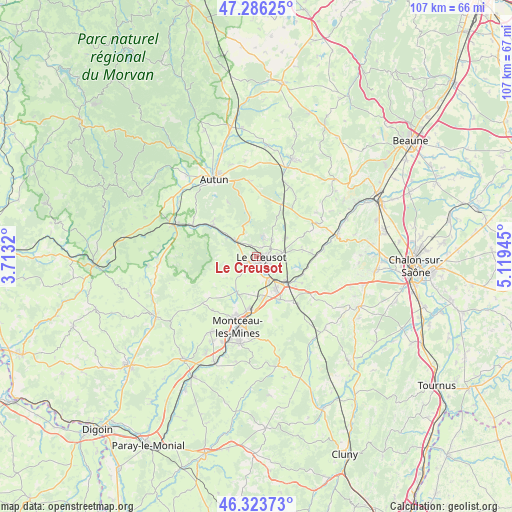
Le Creusot GPS coordinates[2]
46° 48' 25.704" North, 4° 24' 58.752" East
| Map corner | latitude | longitude |
|---|---|---|
| Upper-left | 47.28625°, | 3.7132° |
| Center: | 46.80714°, | 4.41632° |
| Lower-right: | 46.32373°, | 5.11945° |
| Map W x H: | 107×107 km | = 66.5×66.5mi |
| max Lat: | 51.07786° ⇑57.1% North |
| Le Creusot: | 46.80714° |
| min Lat: | ⇓42.9% South 41.3874° |
| min Long | Le Creusot | max Long |
| -5.08615° | 4.41632° | 9.52242° |
| W 71.5%⇐ | ⇒28.5% E |
Elevation
Elevation of Le Creusot is 367 m = 1204 ft, and this is 173.3 m = 569 ft above average elevation for this country.
| Max E: |
2333 m = 7654 ft | 13.5% |
| Le Creusot | 367 m 1204 ft | |
| Avg. | 193.7 m = 635 ft | |
Min E: |
-1 m = -3 ft | 86.5% |
See also: France elevation on elevation.city.
Geographical zone
Le Creusot is located in North temperate zone (between Tropic of Cancer and the Arctic Circle). Distance of this North polar circle is 2196.7 km =1365 mi to North.| Distance of | km | miles | from Le Creusot |
|---|---|---|---|
| North Pole | 4802.6 | 2984.2 | to North |
| Arctic Circle | 2196.7 | 1365 | to North |
| Tropic Cancer | 2598.5 | 1614.6 | to South |
| Equator | 5204.5 | 3233.9 | to South |


Nearby cities:
15 places around Le Creusot: (largest is in red/bold)
• Antully
10.7 km =6.6 mi,  357°
357°
• Blanzy
12.1 km =7.5 mi,  190°
190°
• Broye
12 km =7.5 mi,  306°
306°
• Le Breuil
4.1 km =2.5 mi,  90°
90°
• Marmagne
5.5 km =3.4 mi, 306°
• Montcenis
3.1 km =1.9 mi,  225°
225°
• Montchanin
7.6 km =4.7 mi,  147°
147°
• Saint-Eusèbe
11 km =6.8 mi,  161°
161°
• Saint-Firmin
4.7 km =2.9 mi,  58°
58°
• Saint-Leu
10.7 km =6.6 mi,  142°
142°
• Saint-Pierre-de-Varennes
7.4 km =4.6 mi, 58°
• Saint-Sernin-du-Bois
3.9 km =2.4 mi,  18°
18°
• Saint-Symphorien-de-Marmagne
7.4 km =4.6 mi,  298°
298°
• Torcy
5.1 km =3.2 mi, 146°
• Écuisses
10.9 km =6.8 mi,  121°
121°
Sources, notices
• [Note1] Compared only with cities in France existing in our database
• [Src1] Map data: © OpenStreetMap contributors (CC-BY-SA)
• [Src2] Other city data from geonames.org with taken over terms of usage.
• [Src3] Geographical zone / Annual Mean Temperature by Robert A. Rohde @ Wikipedia
